Upper Sierra Ancha Mountains
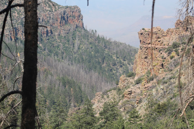
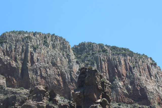
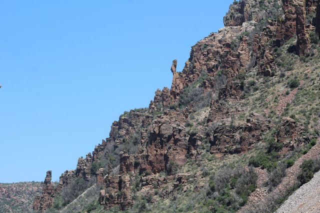
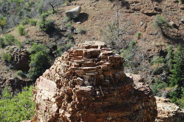
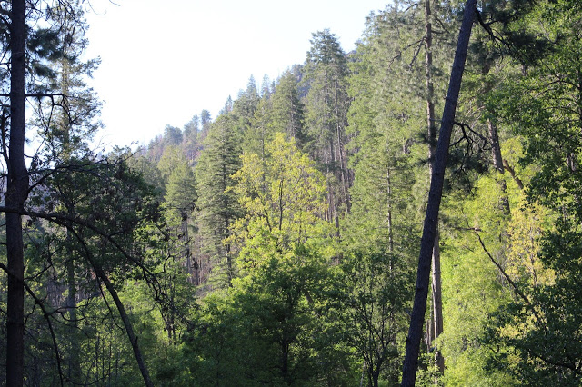
The Sierra Ancha Mountains of the Tonto National Forest are a paradise for the intrepid birder and for folks who love to explore. In Spanish, Sierra Ancha means "broad range". True to it's name, this mountain range extends above it's surroundings of lowland desert and other habitats and sticks out if looking at them from afar. It has endless ridges and scenic canyons to explore. A variety of neat rock formations along cliffs catch eager eyes and halt them in their steps to stare, and the views from the Sierra Ancha high point at the 7,694' Aztec Peak are mesmerizing. The Sierra Anchas have cool creeks to explore or wade along while escaping summer heat, and miles and miles of pine, fir, and oak forests to bird in. The streams of Workman Creek and Reynold's Creek offer a magnificent setting for birding, and they are joined by a handful of other great locations in this birding area.
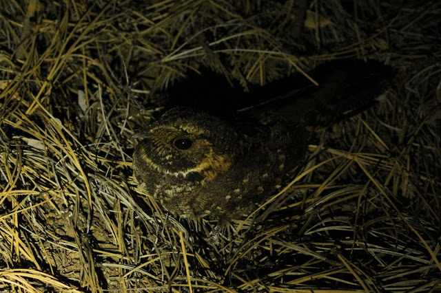
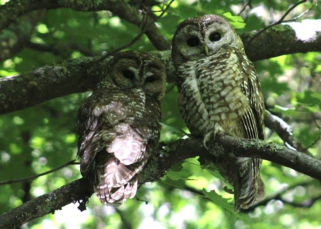
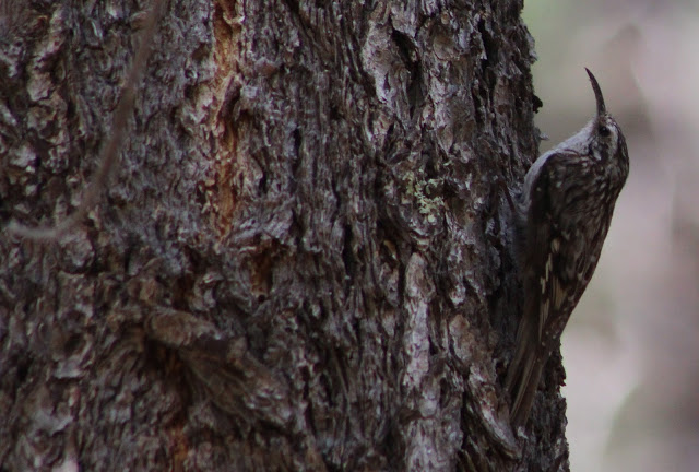
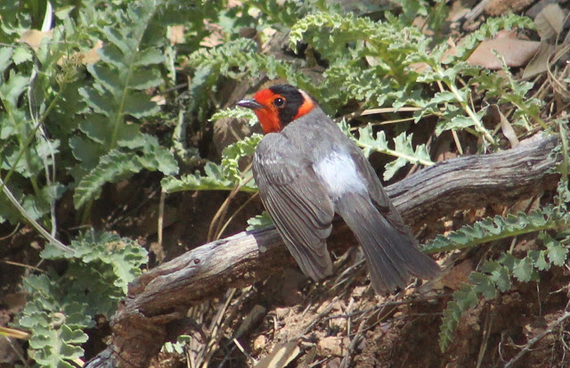
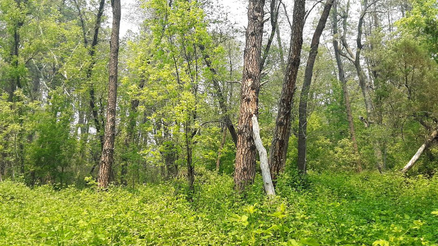
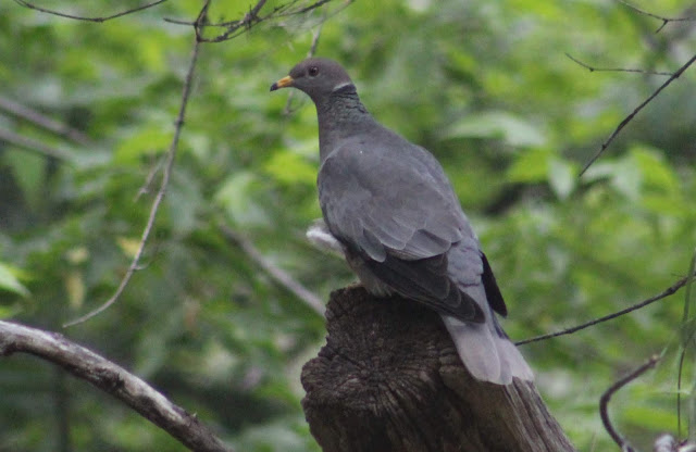
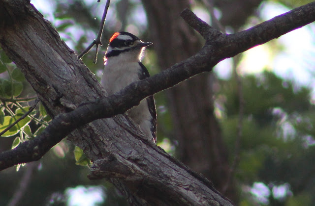
One will bird the Sierra Anchas to look for species typical of montainious terrain in habitat settings of pine, fir, and oak forest, mid to high elevation riparian, and chaparral and juniper slopes in lower reaches. Some of the breeding avifuana in this area include Wild Turkey, Band-tailed Pigeon, Common Poorwill, Mexican Whip-poor-will, White-throated Swift, Black-chinned and Broad-tailed Hummingbirds, Common Black Hawk, Flammulated, Northern Pygmy, and Spotted Owls; Acorn, Downy, and Hairy Woodpeckers; Greater and Western Wood-Pewees, Cordilleran Flycatcher, Dusky-capped Flycatcher, Cassin's Kingbird, Gray, Hutton's, Plumbeous, and Warbling Vireos; Steller's and Mexican Jays, Mountain Chickadee, Violet-green Swallow, Bushtit, all three Nuthatches, Brown Creeper, Blue-gray Gnatcatcher, Canyon, Bewicks, and House Wrens; Western Bluebird, Hermit Thrush, Olive Warbler, Black-chinned Sparrow, Dark-eyed Junco, Rufous-crowned Sparrow, Spotted Towhee, Scott's Oriole, Grace's, Black-throated Gray, Virginia's, and Red-faced Warblers, Painted Redstart, Hepatic and Western Tanagers, and Black-headed Grosbeak. Migration and winter are just as worth the exploring as spring and summer, as the Sierra Ancha are very underbirded. Rarities that have been found here in the past have been Eared Quetzal, Short-tailed Hawk, and Sulphur-bellied Flycatcher.
Directions: The base point for the directions of this birding area will be at the intersection of Highway 188 and Highway 288. Highway 188 is accessed at the west side of Globe and it is taken north of Highway 60 in Globe for about 15 miles to it's junction with Highway 288, which Highway 288 veers to the east direction and up into the Sierra Anchas. Highway 288 is also known as the Globe/Young Highway, and mileages and directions will be given to each birding area from this intersection where the southern limit of Highway 288 begins. If accessing Highway 288 from the north side of Highway 188, Highway 188 can be taken for 46 miles south past it's junction with Highway 87/Beeline Highway. The Highway 87 and Highway 188 intersection is 15 miles south of the town of Payson. Last, the final source of direction to access the Sierra Anchas will be from the town of Young, which is also along Highway 288 and roughly 15 to 28 miles north of the described birding areas in the Sierra Anchas. It is just as good as an alternative direction, but Globe is the route that most people will take to get into the Sierra Anchas.
BIRDING LOCATIONS
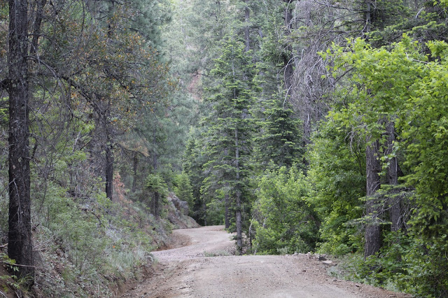
-Forest Road 489: Follow Highway 288 for 18.7 miles north past Highway 188. This road will be on the east (right) side of Highway 288, and it is what really begins the stretch of high elevation habitats in the Sierra Achas. Follow this road for more than a mile to it's end. Most of the road is rough for vehicles other than the first quarter-mile of the road. It is recommended to park at the beginning of the road and hike up for the birding adventure. Pocket Creek flows adjacent to the road, and mid to high level riparian habitat dominated by sycamore lines the creek. The woodlands are thick around the creek, and the road climbs from oak and juniper up into pine and Douglas fir habitat. A variety of birds are readily found here. Interestingly, this road has yet to knowingly attract Red-faced Warbler and Cordilleran Flycatcher in the middle of breeding season, despite the fact that there seems to be appropriate habitat (both species are common in canyons just north of this road).
-Parker Creek Trail #160: At 20 miles of driving on Highway 288 past Highway 188, this trailhead will be on the east (right) side of 288 immediately following an ADOT yard. Park at the Parker Creek Trailhead, and find the trail on the southeast side of the parking lot. The trail can be a little hard to find at first but some walking around will do the trick to find the trail. This trail starts off in juniper and chaparral settings and it climbs up into thick pine and fir forest. Most of the trail parallels the lush Parker Creek, which is harbored in midst of a narrow and scenic canyon that is full of memorable views and epic rock formations. The hike here is for the intrepid birder, and it is advised to not hike in this area alone. There is no cell phone reception here, and this is one of the more remote hikes in the Sierra Anchas. On top of that, the trail goes through sections of previously burned forest. In many places, the regrowth of the burn covers the trail and it can be challenging to navigate. This trail can be hiked one way for more than four miles, and a high variety of birds may be seen due to a change of about 1,500' in elevation.
-Parker Creek: At roughly 20.2 miles of driving on Highway 288 past Highway 188, Parker Creek comes alongside the road. Parker Creek has a thick and lush riparian woodland with an interesting undergrowth different from many other riparian woodlands in Arizona. Oak, juniper, and chaparral surround the riparian habitat. Look and listen for a variety of birds here throughout the year. Dusky-capped Flycatchers are seen and heard regularly in spring and summer. This is a perfect place for people to enjoy birding from the road.
-Forest Road 142: Just past Parker Creek at 20.4 miles of driving on Highway 288, this small road will be on the west (left) side of 288. The start of the road has a small stretch of riparian habitat before it goes out to chaparral and juniper habitat. This is a short walk, 0.3 miles one way in total before the road stops. Look and listen for birds like Gray Vireo, Black-chinned Sparrow, Rufous-crowned Sparrow, and Scott's Oriole.
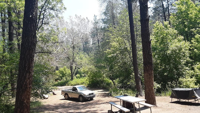
-Sawmill Flats Campground: When getting into the Upper Sierra Anchas, there is a habitat mix of chaparral and juniper slopes, upper riparian woodlands, and canyons harboring mixed coniferous forests. Just before and right at 23.1 miles of driving on Highway 188 north and from Highway 188, 288 enters pine and oak woodland for the next seven miles. It is a beautiful drive. At the 23.1 miles, Sawmill Flats Campground will be on the left side of 288, and it offers the chance to camp (no fee) and bird here and nearby.
-Forest Road 671 (also known as FR 95) and Rose Creek Campground: At 24.2 miles on Highway 288 past Highway 188, these two locations will be on the west (left) side of 288. Forest Road 671 (which is labeled as Forest Road 95 on Google Maps) is barely south of the turnoff to Rose Creek Campground, and it doesn't stick out as much when driving along the road. Both are good birding spots. Rose Creek Campground is a great place to camp out at when birding in the Sierra Anchas. It has nearby pine and oak forest as the dominant habitat, a small stand of Douglas fir on the west side of the campground that attracts Red-faced Warbler, and a peaceful creek lined with sycamore and other riparian trees. Forest Road 671 is easy to follow, but is a challenging hike with big elevation increases and decreases. It's a great road to bird on, and it can be taken for about five miles through a good mix of habitat that include pine and oak forest, juniper/oak and chaparral slopes, and mixed pine,fir, and aspen forest in the higher elevations of the hike. FR 671 climbs to the northwestern direction for much of the way overall although the route takes plenty of turns in the southwest direction too. If hiking and birding along this route, plan to see a variety of birds. FR 671 is a location that could truly use more coverage by birders.
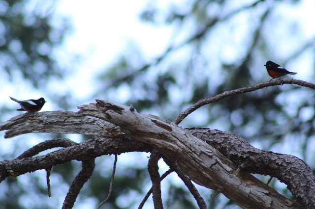
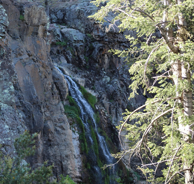
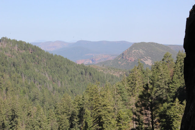
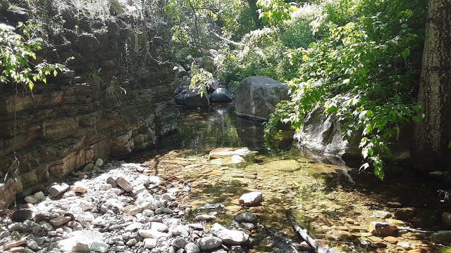
-Forest Road 487 (Workman Creek Road): This road is the most popular route in the Sierra Anchas for most visitors. It comes at 25.6 miles of driving on Highway 288 past Highway 188, and is on the east (right) side of 288. Forest Road 487, also known as Workman Creek Road, is a route of scenic beauty. Workman Creek flows along the road for over half of the route up this road, which travels for about 6.5 miles to the 7,694' Aztec Peak. The base of Workman Creek Road at it's intersection with Highway 288 is at about 5,500' and the gradual but noticeable change in elevation along the route is interesting to see. For the first three miles, Workman Creek lies in midst of a canyon. It starts off in what is dominantly pine, oak, and some Douglas fir along with the creek which is dominately lined by sycamore. Heading east and traveling FR 487 results in the slopes getting steeper and the forest becoming a dense mix of pine and firs. Painted Redstart, Red-faced Warbler, Cordilleran Flycatcher, Western Tanager, House Wren, and many other species are abundant. There are four eBird hotspots along the route, all of which are worth birding. The first half-mile of FR 487, the lower portion, is worth birding. Park along the beginning of the road and walk east. There are three day use sites along this stretch, all of which are also eBird hotspots. The Creekside Day Use Site comes at 0.8 miles on FR 487, the Cascade Day Use Site comes at 1.7 miles, and the Falls Day Use Site comes at 2.4 miles. None of these locations allow camping, they are day use only. After the three day use sites, FR 487 becomes very rough in parts. A high clearance vehicle is close to a must. At three miles of driving FR 487, the road drives over Workman Creek Falls. This is a spot where Workman Creek flows over a cliff and into it's harboring canyon, and there is a variable waterfall that has little to impressive flows for 200 feet back down into the canyon. The falls are a scenic must to visit, and White-throated Swifts fly around the cliff edges quite often. For folks that have a faint heart when it comes to heights, it is probably best to stay within the lower reaches of FR 487. Past Workman Creek Falls, FR 487 continues on for more than three miles to the summit of Aztec Peak. Past the falls are impressive stands of mixed coniferous forest and aspen, as well as an area that was previously burned. This stretch is also an eBird hotspot, and a Greater Pewee can often be found here. The road soon makes a drastic and steep climb for a distance, and goes through a thick section of an impressive deciduous forest. Close to four miles on 487, the road does flatten and there are camping areas in midst of pine, fir and oak forest at elevations of close to 7000'. At six miles the road climbs drastically again up to the summit of Aztec Peak. At 7,694', Aztec Peak (eBird hotspot) is the highest point in the Sierra Anchas and is worth a visit. The road has rough stretches up to the peak to equal out it's final tally of 6.5 miles of traveling on. Aztec Peak has a fire tower and incredible views of not only the Sierra Anchas, but for miles and miles in every direction. This summit hasn't been birded much, but one birding effort did have the discovery of a very rare Short-tailed Hawk (Grant Loomis).
-Honey Creek Divide: At 26.4 miles of driving past Highway 188 on Highway 288, Honey Creek Divide will be on the east (right) side of 288. It is another place to camp in the Sierra Anchas and it falls between two of the best roads in the area (FR 487 and FR 410). Pine and oak forest surround Honey Creek Divide, and roads that branch off to the east take the birder through chaparral, oak, and juniper habitats before climbing in elevation up to ridges that harbor mixed coniferous forest on the slopes.
-No Name Drainage: At 26.9 miles of driving on Highway 288, 288 will take a bend to the left. On the north side of the road, there is a pull off as a thick drainage full of pine and fir come into contact with the road. By studying a map, venture a steep downward to the north down a slope to access the drainage. There is a small creek that has running water in places and there is good potential for birding by walking along the creek to the north and south. Birding along the road at the pull off at night can be good for Mexican Whip-poor-will.
-Hell's Hole Trail #284: At 27.6 miles of driving on Highway 288, this trailhead will be on the west (left side of 288). There is pine and oak forest as the dominant habitat for the first mile of the trail. By reading over trail descriptions, the trail does meet up with the western side of Workman Creek and it drops down into a scenic and rocky canyon. It is a location that needs more hiking and exploring in order to be described better. Birds of pine and oak will be plentiful, and Flammulated Owl has been heard here at night.
-Forest Road 410 (Reynold's Creek Road): At 27.7 miles of driving on Highway 288 past Highway 188, this road will be on east (right) side of 288 after crossing Reynold's Creek. Forest Road 410 runs from west to east for about four miles before it dead ends at the Reynold's Creek Trailhead. In similar ways to Forest Road 487 and Workman Creek, this is an epic road that is harbored beneath tall forested slopes full of pine and fir and is paralleled by a sycamore-lined creek that is in this case a beautiful creek called Reynold's Creek. It takes up to a half mile of driving or hiking along this road for the road to traverse immediately along the creek. Forest Road 410 is a decent dirt road to travel on, but there are parts where it is extremely rough. The toughest stretch for vehicle travel comes in the last mile. To avoid driving the rougher stretch, drive 2.5 to 3 miles in, park, and walk the rest of the road. This route is incredibly scenic, and walking the road in spring and summer will result in great numbers of high elevation species. A morning of seeing Band-tailed Pigeon, Acorn and Hairy Woodpecker, Cordilleran Flycatcher, Steller's and Mexican Jay, Brown Creeper, House Wren, Virginia's, Grace's, and Red-faced Warblers; Painted Redstart, Western Tanager, and Black-headed Grosbeak among other species makes for a worthy time. Sulphur-belled Flycatcher has also been found here before in the sycamores along the creek (Troy Corman). At the end of the road is the Reynold's Creek Trailhead. The Reynold's Creek Trail can be taken east of the trailhead for some distance, but it is poorly marked and hard to follow. Right on the immediate southeast side of the trailhead is a wide trail that heads south for about a mile and into a heavily forested slot canyon that ends at a small waterfall. It is worth the hike. Also, just after walking for a short distance from the start of the wide trail, there will be a rough forest road that veers to the right (northwest direction). It goes along the northfacing ridge that borders the southern side of FR 410, and it traverses along the ridge and over the ridge for over three miles toward Honey Creek Divide. It goes through a habitat variety, including several stands of deciduous forest.
-Circle Ranch/McFadden Trailhead: At 27.8 miles of driving on Highway 288, this trailhead will be immediately north of the turnoff to FR 410. It is on the west side of 288. Birding around the parking lot as well as hike some of the trail can be productive. The trailhead has access points where one can bird along McFadden and Reynold's Creek. Look for pine and oak species and keep an ear out for sycamore-loving species like Dusky-capped Flycatcher and the rarer possibility of Sulphur-bellied Flycatcher. If taking the trail to the west and northwest of the trailhead, it goes along McFadden Creek through pine and oak woodland before entering much sparser habitat that consists of chapparal and juniper.
-Highway 288 (Mile Markers 287-289) At 28-30 miles of driving on Highway 288, there are good birding opportunities by simply walking along 288 in midst of pine, fir, and oak forest. While there are sections of private property off of the road during this stretch and limited forest roads also along this stretch, birding along the road is ideal. In the past, day time birding was productive and easy to walk, and driving the road and stopping at pull offs at night may be effective for owling. Flammulated Owl has been heard in several places along this section of 288 by pulling off of the road and listening.
-FR 609 (and FR 486 access): At 34 miles of driving on Highway 288 past Highway 188, Forest Road 609 will be on the west (left side) of 288. Forest Road 609 traverses for over ten miles through an area that has rarely been birded. Most of the habitat consists of pine and oak woodland with sides of chapparal and juniper, as well as sycamore-lined creeks. To travel on this road, a high clearance vehicle is highly recommended. Most of the road is in good shape up to 7.5 miles of driving west from Highway 288, but there are some stretches that are very rough and this area is one that is extremely remote. At 6.1 miles of driving west on FR 609, the road comes into contact with the north/south road of FR 486 on both sides of FR 609. Forest Road 486 is a fun road to explore, and on FR 486 to the north of FR 609, FR 486 travels by landmarks like East Lacy Fork, Salt Log Canyon, and Pine Flat Tank. The south side of FR 486 is fun to explore too. Do not travel per vehicle on the north side of FR 486 without a jeep or a truck that has great clearance. Continuing west on FR 609 for 7.5 miles, the road intersects with FR 236 at a small grassland area, which goes south. This road also goes through pine and oak woodland and chapparal areas and it even goes to the landmark of an old homestead that is called the Dupont Cabin after 4.6 miles of traveling, a place that is said to be awesome per reviews. Use caution when exploring this entire area, as it is truly in the middle of nowhere.
This upper section of the Sierra Anchas can also be accessed from the town of Young. Young is at 47.6 miles of driving north on Highway 288 past Highway 188. As a reminder, Highway 288 is also known as Forest Road 512, or the Globe/Young Highway. If going heading south to the Sierra Anchas from the town of Young, a few mileage distances will be described to give one a feel of distance if coming from the northern direction. For example from Young to FR 609 (FR 609 is the furthest spot north in this birding area) is 13.6 miles. Young to FR 410 (Reynold's Creek Road) is 19.9 miles. Young to FR 487 (Workman Creek Road) is 21.9 miles. Last, Young to FR 489 (the southern-most point in this birding area) is 28.8 miles.
Back to Gila County Birding Areas |


