Slate Creek Divide Area Maps
*All maps owned by Google
Welcome to the Slate Creek Divide Area. These directions will help you find the areas to bird in the better spots this location has to offer, and will increase your birding luck.
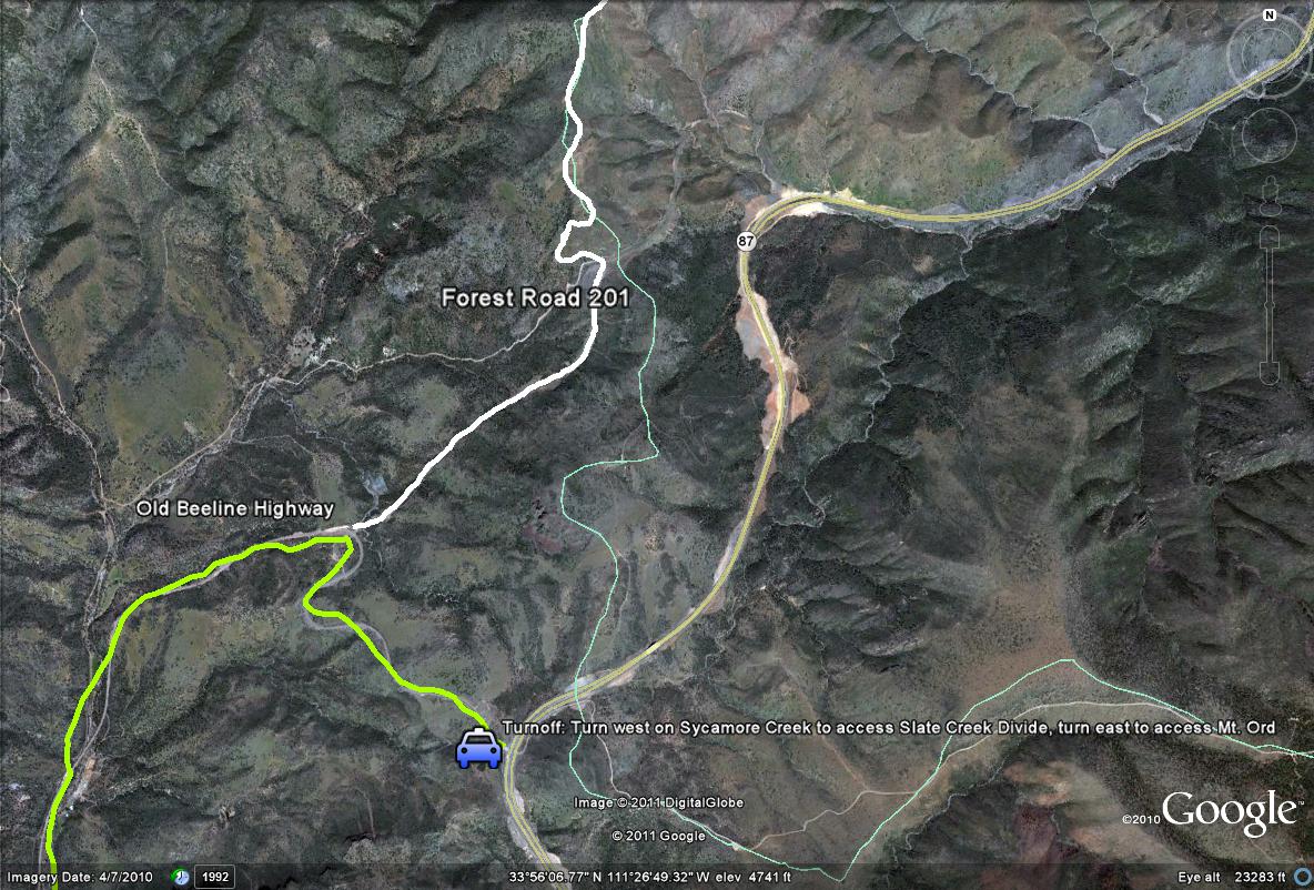
Map #1-Turnoff Overview when accessing the Slate Creek Divide Area
Turnoff Overview: This map illustrates the turnoff to access the Slate Creek Divide Area. When coming north or southbound up or down Highway 87 (Beeline Highway), the turnoff to the Slate Creek Area is located just north of mile marker 222 on the highway. Here a turnoff will be seen that is marked for both Sycamore Creek (a turn to the west) as well as Mount Ord (turn to the east). After taking the Sycamore Creek turnoff west, the paved road is part of the Old Beeline Highway (highlighted in LIME-GREEN). Follow the Old Beeline Highway west for 1.2 miles until a noticeable dirt road is seen that heads in the northeast direction. This is Forest Road 201. Take this dirt road for 9.7 miles to it's ending point at the Mount Peeley Trailhead, which is part of the Arizona trail. One will start to access the Transition Zone at about 6.7 miles while driving on this road As shown, Forest Road 201 is the IVORY-COLORED path. Gray Vireos, Black-chinned Sparrows, Scott's Orioles, and Crissal Thrashers may be viewed from this beginning stretch.
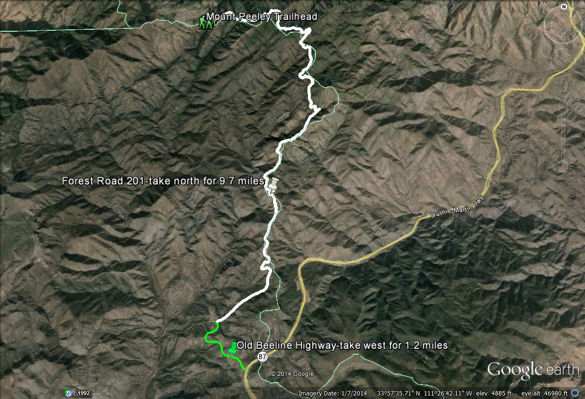
Map # 2: Overall directions of driving through the Slate Creek Divide Area
As mentioned on Map 1, take the Sycamore Creek turnoff west from Highway 87 just north of mile marker 222. Once turning off, the paved road one is on is the Old Beeline Highway. Follow the Old Beeline Highway west for 1.2 miles. Look for a dirt road turnoff on the right side of the road, which is heading in the northeastern direction. Turn right/northeast on this road. This is Forest Road 201. Follow Forest Road 201 for up to 9.7 miles, where it dead ends at the Mount Peeley Trailhead. This trailhead is also part of the Arizona Trail. When driving up on Forest Road 201 towards the Mount Peeley Trailhead, watch for other side roads that branch off to the left. There are three of them. As these side roads meet Forest Road 201, they are always on the left. Just remember to keep right on the main road at this point at all times. These three left side roads are found roughly at miles 1.2, 3.5, and 5.2. Continuing on Forest Road 201, one will reach the Transition Zone and come into contact with pine trees at 6.7 miles. For the last three miles of Forest Road 201, it passes through patches of good mixed conifer and oak forest. At mile marker 7.7, one will come into contact with Forest Road 201-A, a side "road" that heads south into Maricopa County. See maps below this map for more information.
Slate Creek's Transition Zone areas that are in Maricopa County:
Slate Creek Divide is mostly in Gila County once the Transition Zone is reached. Most of Forest Road 201 is in Gila County after the 6 mile mark. Maricopa County is always close to this road, however. The Gila County side has outstanding birding in the burned and live patches of Douglas fir forest along the road also. For the Maricopa lister, one will have to get themselves in for more serous hiking.
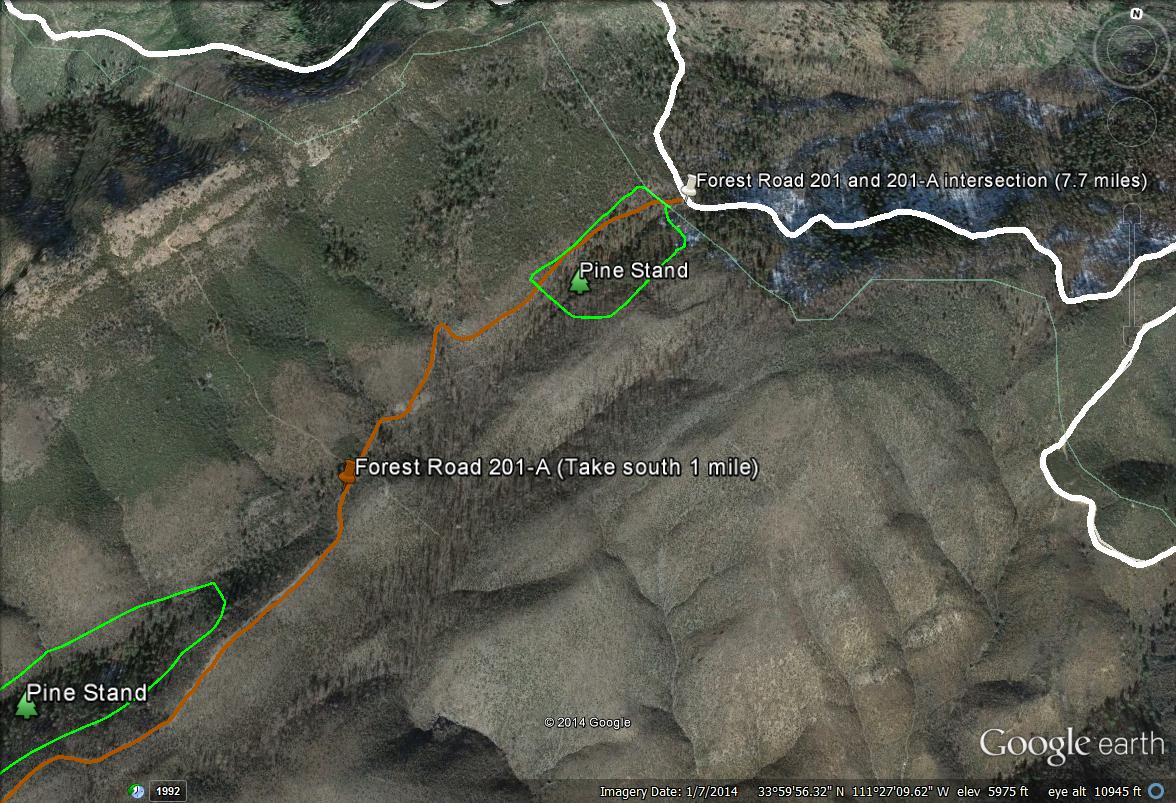
Map #3: Forest Road 201-A
Once driving up Forest Road 201 for a good distance and reaching the spot where the good forest habitat really starts to begin, one will soon come across a side road that is accessed from FR 201, that is named Forest Road 201-A. This road is entirely Maricopa County just after entering the road a short distance. This road's surrounding habitat was burned by the Sunflower Fire in 2012 and used to be an excellent birding spot. Despite the fact most of it has been burned, it still passes through good forest habitat in places, especially within the first 1/4 mile. There is a stand of pines here at the beginning, which is good for pine loving species such as Grace's Warbler, Hepatic Tanager, and more. Further down the road south about a half mile to 3/4 mile, is another stand of pines. Forsest Road 201-A continues on for a good distance past the forest habitat, heading in the southwest direction. Chaparral and juniper species may be observed along this road also. The best birding along this road takes place within the first mile of walking. The hike has a few minor climbs and drops in elevation on the road, but is otherwise pretty flat. Also, great views of the surrounding Slate Creek area and Mazatzal Mountains are viewed nicely from this road!
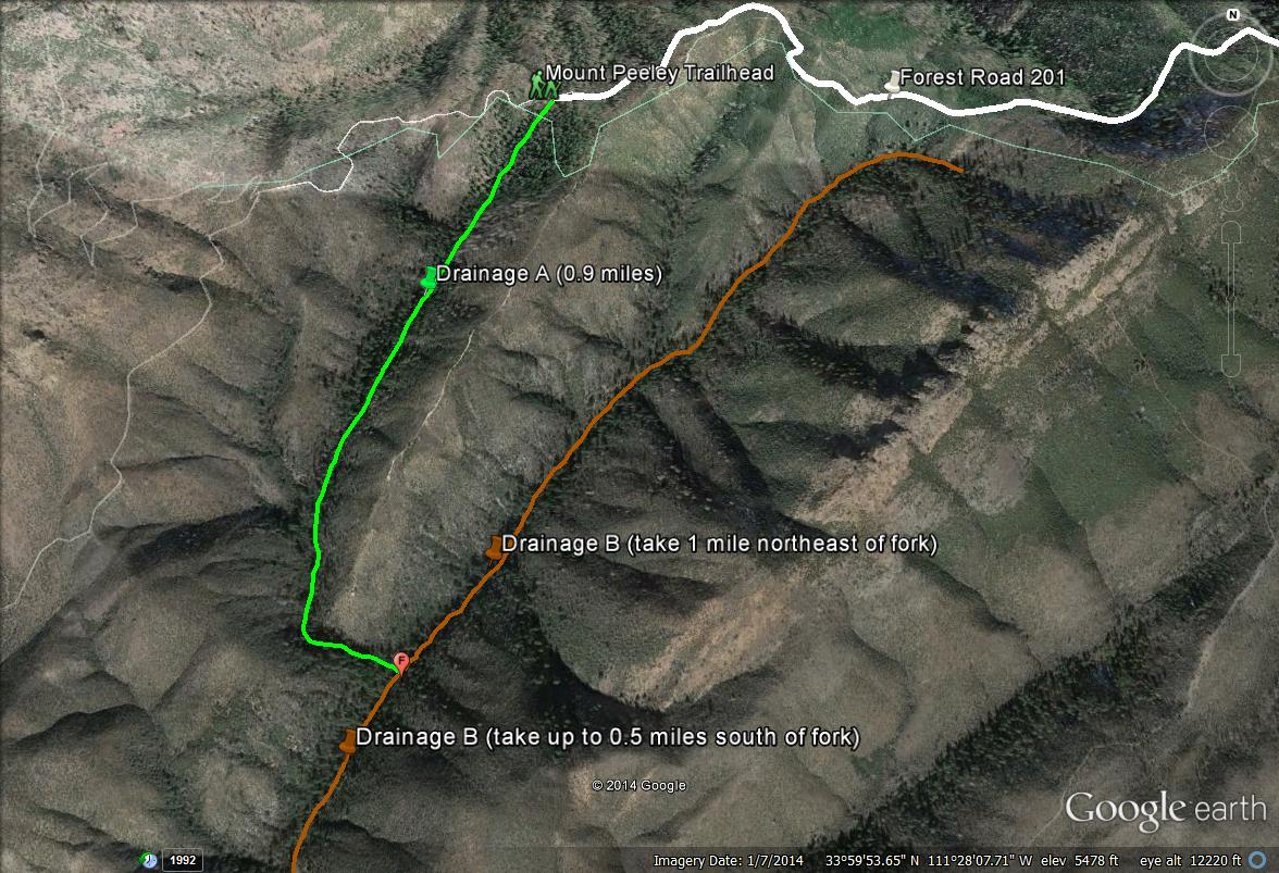
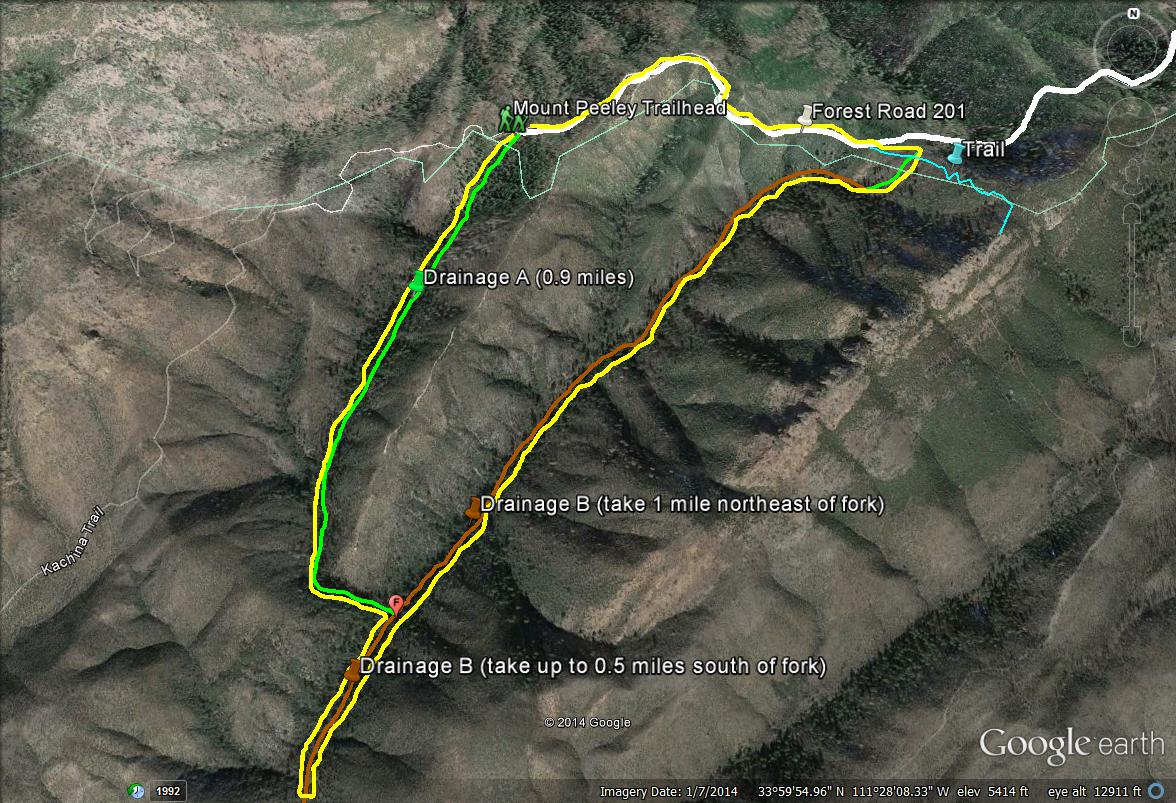
Map # 4: Some of Maricopa's best habitat: the two Slate Creek Divide drainages south of the Peeley Trailhead
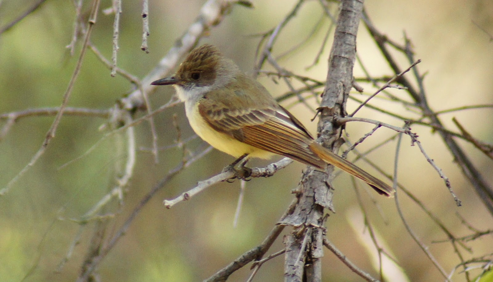
This map shows two drainages at Slate Creek Divide that hold some of the very best habitat that is to be found in Maricopa County. In the 2012 Sunflower Fire, the fire burned around the drainages, but luckily, it didn't touch these two drainages at all. Both drainages hold a significant breeding population of Dusky-capped Flycatchers, which is currently Maricopa County's only known breeding location for this species. Dusky-capped Flycatchers mainly range in the southeastern part of Arizona, but are expanding their range northward in several areas of central Arizona. Like southeastern Arizona, these two Maricopa County drainages hold very similar habitat makeups that include Douglas fir, ponderosa pine, oak, and Arizona sycamore. With this habitat selection, the potential is very high for unusual birds in the Maricopa County region. This drainages are also very good for viewing Mexican Jay, another species that is scarce in the county. With the Douglas fir habitat (the most dominant tree in here), these drainages hold breeding habitat for Red-breasted Nuthatch and Brown Creeper also, which don't breed elsewhere in the county. Spotted Owl and Red-faced Warbler have also been found, and may potentially breed in these drainages now or in the future.
To see these birds and habitat, one needs to hike down the drainages, and they are accessed directly south from the Mount Peeley/Arizona Trail trailhead. The hike is challenging to very difficult, as one will have to climb over logs and rocks in places. There are plenty of hazards in the area (see below). The first drainage, Drainage A, is the one that is accessed from the Trailhead. It heads south for 0.9 miles and ends at the other drainage, which is titled Drainage B. In the 0.9 miles, Drainage A is a fairly difficult hike, but it can be handled by a majority of people. There are steep climbs over rocks and bushwhacking spots in a few places, but it is otherwise a gradual walk down for the 0.9 miles to Drainage B. Once Drainage B is reached, one has two options at the fork of both drainages. One is to head south down Drainage B, and the second is to head north up Drainage B. If one is in for the adventure, it is a good idea to take both, starting with going south for up to a half mile down Drainage B. There are good stands of Arizona sycamore along this stretch in midst of fir, pine, and oak. The good habitat starts to end and the hiking gets a lot more rough as one hikes almost a half mile south of the fork down Drainage B. If hiking up Dranage B north of the fork for both Drainages, the drainage may be followed for close to a mile. Like Drainage A, taking Drainage B north of the forks is more of a pleasant but still challenging walk for the first half mile but the latter half is very difficult. Halfway down this stretch, the habitat gets a lot more steep, thick, slippery, and is much more hazardous. If hiking here, be very careful. If hiking to the very northeastern limit of Drainage B, one may have an easier way to climb up and out of the drainage to quickly access Forest Road 201. On Forest Road 201 at this point, it is only a half-mile walk back west to the Peeley Trailhead. See the next map, Map # 5, for a better overview. A third option would be to hike down Drainage A to the fork of both drainages, and then take Drainage B both north and south of the fork for shorter distances. Once taking Drainage B both ways for short distances from the fork, then one can return to the fork and head back up Drainage A to the Trailhead and parking area. For a grand tour and challenging hike of both drainages in hiking loop fashion, see Map # 6.
SLATE CREEK DUSKY-CAPPED FLYCATCHER FACTS AND TIPS: The Dusky-capped Flycatchers were discovered in August of 2010 near the fork of the two Drainages, but south of the fork in Drainage B. They were seen later that week feeding young, to confirm breeding in the county. The first year saw about ten birds. The following year in 2011, they were detected in good numbers again, with 7 individuals in May. They were at the southern end of Drainage A, at the fork, and south of the fork in Drainage B. In 2012, they went undetected due to the Sunflower Fire and closed access to Slate Creek. In 2013, numbers were very high, and 16-18 individuals were counted in July. They were at the fork and then oddly north of the fork and well spread out up Drainage B. 2014 then saw about 8 birds in May, at the south side of Drainage A, at the fork, and in Drainage B shortly south of the fork. There are likely 4 to 5 pairs of these flycatchers in the drainages annually, and the number of young fledged is an interesting thought too. Overall, the best place to get a Maricopa County Dusky-capped Flycatcher here would be to hike down to the area of the fork. The mournful song of the flycatcher can't be missed!
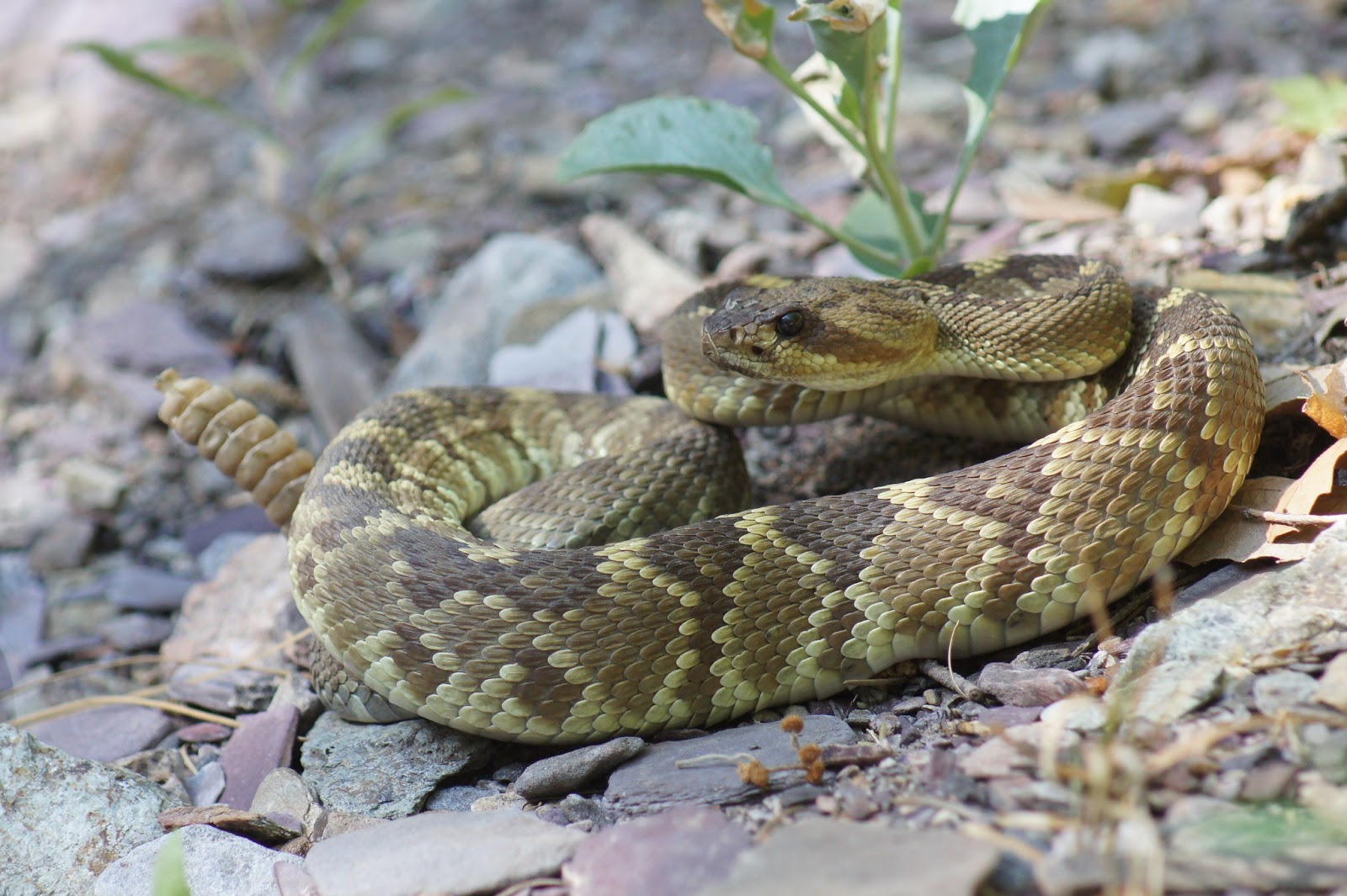
HAZARDS: The drainages at Slate Creek are a very tiring and exhausting hike. Bring plenty of food and water. Don't take life for granted here, never come down these drainages alone. There are spots were the habitat is very thick and hard to get around and will scratch people up a bit. Sections of the hike are rocky and canyon like with loose rocks in many places, making it an easy place to slip and fall. Dangerous wildlife includes Rattlesnakes (in abundant numbers), Black Bears, Mountain Lions, Scorpions, as well as Poison Ivy. Cell phone signal is usually dead down in the drainages as well. On a positive note, cell phone signal can usually be very good from Forest Road 201, depending on what service is used. The picture below is of a Black-tailed Rattlesnake in Drainage B, south of the fork.
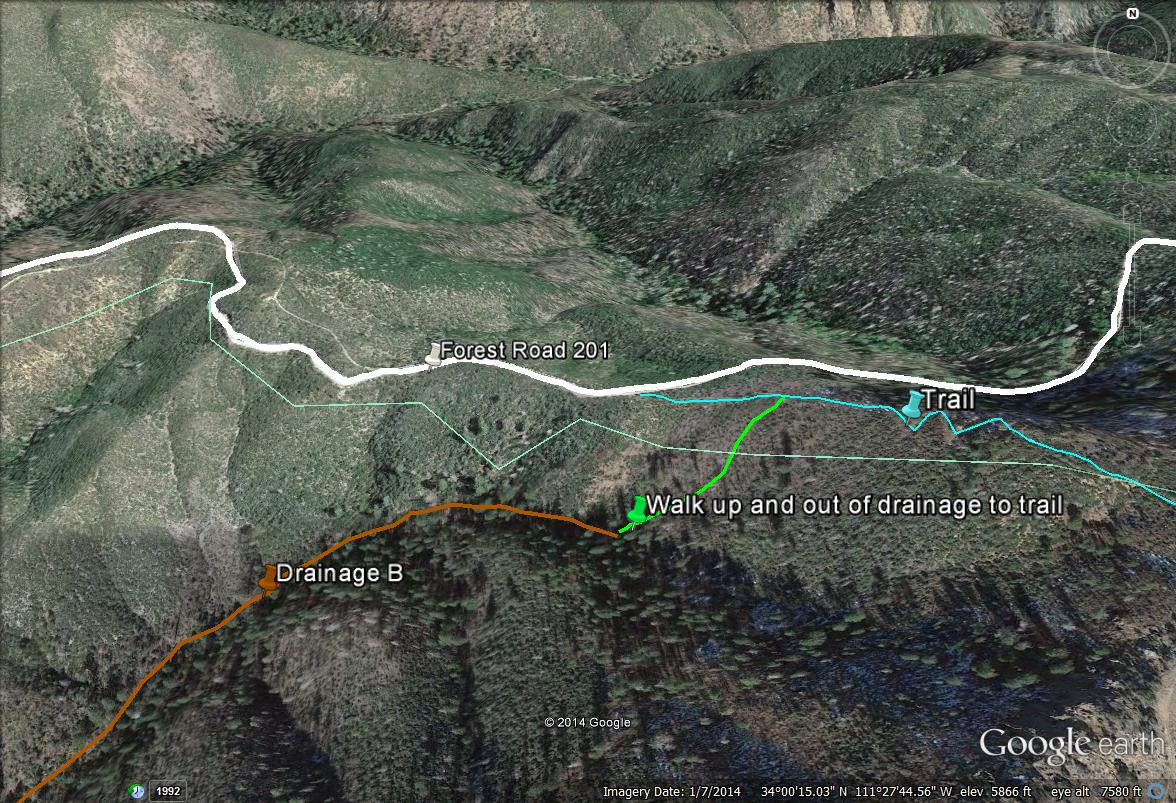
Map # 5: Climbing out of the northeastern section of Drainage B
If walking to the very northeastern section of Drainage B, one has a convenient and much quicker route to get out of the drainages. One will know when Drainage B is reaching it's ending point. There is a horrible stretch of habitat to bushwhack through before the very last stretch. Towards the end, there are steep climbs in the area of the drainage but it isn't as thickly vegetated everywhere. Once one comes close to the end, the drainage will go upward. Follow it upward a short distance. If looking northwest, Forest Road 201 may be seen a very short distance away. The problem is is that there is thick chaparral habitat between the drainage and road. By studying this map or having a GPS, there is a steep but do-able climb up to the east of the drainage up to a ridge that leads to a trail. By climbing up this way, the vegetation isn't as thick as a straight shot up to Forest Road 201 through chaparral. The chaparral will cut a person up very badly. By walking up to this east ridge from the drainage, it saves energy and horrible bushwhacking. Once the trail is found, take it down to the north and back to Forest Road 201. From here, it is about a half-mile walk west to the Mount Peeley Trailhead.
Map # 6: Complete Drainage A and B loop hike
This hike is long and tiring, but the birding is very rewarding. Refer to maps 4 and 5 for this loop also. It helps to be familiar with the area also when trying to hike this loop. Once parking at the Peeley Trailhead, take Drainage A south for the 0.9 miles. Once at the fork of the two drainages, take Drainage B for a distance (probably 0.5 miles at the most) south past the fork. Once completing it, head back north and past the fork. Then, work the rest of Drainage B for a mile north past the forks. When reaching the eastern limit of Drainage B, take the suggested route out of Drainage B as illustrated on Map 5 back to Forest Road 201. Once on Forest Road 201, walk about a half mile west back to the Peeley Trailhead. Altogether, this loop hike is about 3.3 miles. It's not a long distance, but the bushwhacking and climbing make it feel like a much longer hike. On the map below, the yellow line illustrates the loop hike.
|


