Pinal Mountains
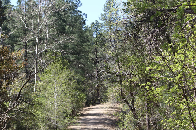
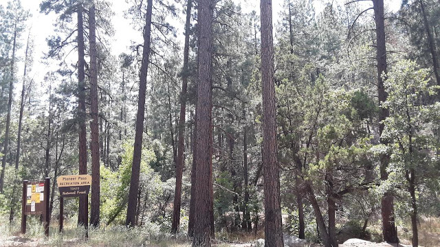
Just to the south of and towering over the city of Globe are the spectacular Pinal Mountains. This mountain range is a summer escape from the heat, and the summit of the area comes at the 7,848' Pinal Peak. Without any other mountanious neighbors closely nearby and with it's separation from other high elevation areas, the Pinal Mountains are like a sky island. Although they are smaller than the likes of the well-known southeastern sky islands themselves such as the Santa Catalina, Santa Rita, Chiricahua, and Huachuca ranges, these mountains do offer a sampling of birdlife that one would find on an adventure to Arizona's southeast. The Pinals are also the highest point of land between the Salt and Gila Rivers before their confluence. In the Pinal Mountain Recreation Area, there are two sides that access the higher elevations of the Pinals: the side that climbs to Pinal Peak as one and the side that climbs to Pioneer Pass as the other. Both sides of these high elevation areas are on north-facing slopes. The upper section of the climb to Pioneer Pass is full of pine and oak forest, and the upper section of the climb to Pinal Peak brings on pine and oak forest too, but it also has much cooler and dense stands of forest that contain fir, aspen, pine, and groves of deciduous trees when the elevation exceeds 7,000'. Although these higher elevations are the main draw to the Pinals, the drive up to the high country gives a round out with habitat diversity, as the foothills contain slopes full of chaparral and juniper, as well as sycamore-dominated riparian woodland along Russell Gulch and Kellner Canyon.
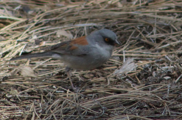
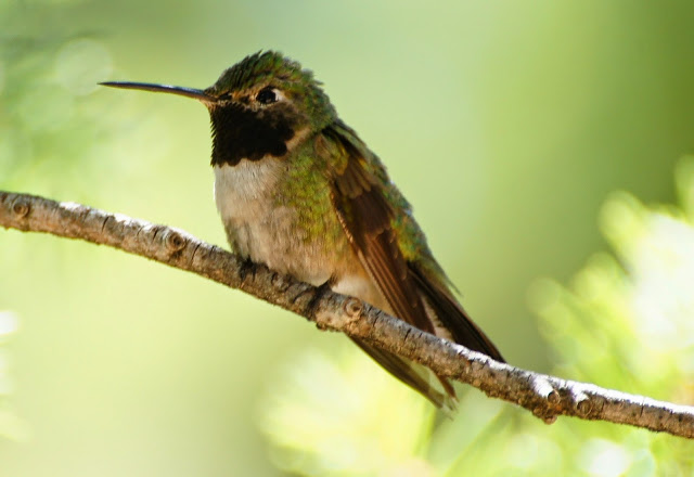
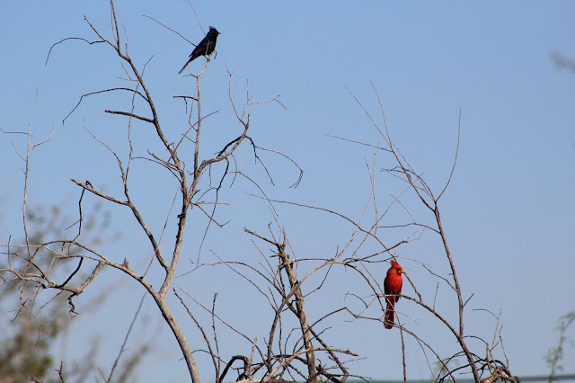
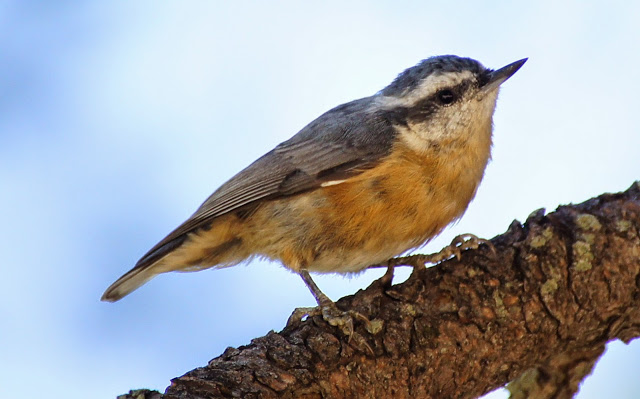
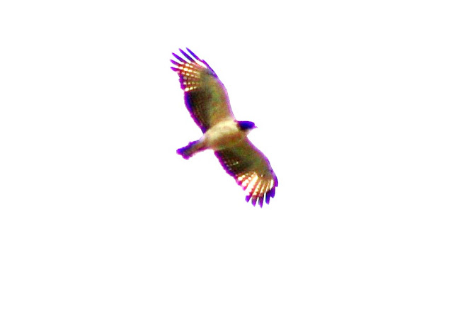
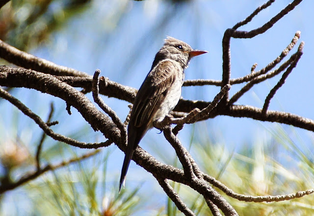
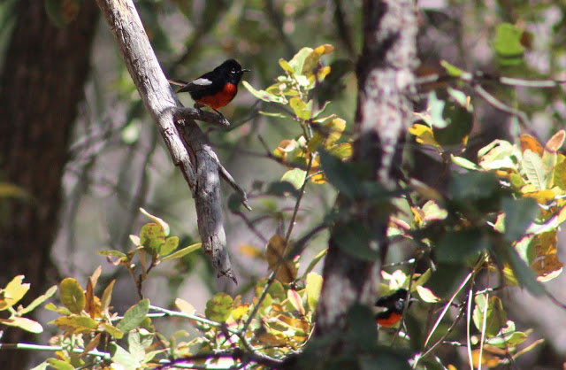
The bird life of the Pinals replicate the scenic beauty and adventure the area has to offer. While birding in the upper elevations, it doesn't take long to realize that the Yellow-eyed Junco is a common bird here. The Pinal Mountains host the northernmost breeding population of this bird, and to go along with it are solid numbers of birds that are considered to have the highest bulk of their range in southeastern Arizona. While the Yellow-eyed Junco is a great example of such, the Pinals also bring notable numbers of species like Rivoli's Hummingbird, Greater Pewee, Dusky-capped Flycatcher, Olive Warbler, Red-faced Warbler, and Painted Redstart. On note of much rarer birds, the Pinals have also hosted Short-tailed Hawks in recent years, who have most likely bred on the mountain due to when an adult and juvenile were both detected in 2018 (Jeff Ritz, Dara Vazquez, Laurie Nessel). Arizona's one and only report of Orange-billed Nightingale-Thrush in 1974, which remains as hypothetical, was observed here (Sighting by G. Nicholson, written about by Gale Monson and Allan Phillips in 1981 publication, Annotated Checklist of the Birds of Arizona). The potential for surprises in this mountain range are high, and in addition to species that are more restricted to central and southeastern Arizona are more widespread forest species of western North America like Northern Pygmy-Owl (Rocky Mountain subspecies), Flammulated Owl, Mountain Chickadee, Steller's Jay, and Yellow-rumped Warbler. To combine more of the diversity of forest birds, one will also observe species in the upper elevations of the Pinals that include Band-tailed Pigeon, Mexican Whip-poor-will, Broad-tailed Hummingbird, Zone-tailed Hawk, Acorn and Hairy Woodpeckers, Western Wood-Pewee, Cordilleran Flycatcher, Plumbeous and Warbling Vireos, Bridled Titmouse, all three Nuthatches, Brown Creeper, House Wren, Red Crossbill, Virginia's and Grace's Warblers, and Western and Hepatic Tanagers. Migration makes for high numbers of species during migrations that includes clearings of wildflowers that are filled with hummingbirds, and winter can occasionally bring in suprises like Clark's Nutcracker. In the lower foothills of the Pinals where the primary habitats consist of juniper and chaparral, watch for species like Juniper Titmouse, Woodhouse's Scrub-Jay, Gray Vireo, Bushtit, Rufous-crowned Sparrow, Black-chinned Sparrow, Black-throated Gray Warbler, Scott's Oriole, and high numbers of Fox Sparrow in winter. The riparian habitat along the lengthy Russell Gulch will host a variety of lower elevation birds like Gila and Ladder-backed Woodpeckers, Brown-crested Flycatcher, Vermilion Flycatcher, Cassin's Kingbird, Bell's Vireo, Yellow-breasted Chat, Yellow Warbler, Northern Cardinal, and Blue Grosbeak.
Directions: This area will be divided into two main sections: the Pinal Peak Route, and the Pioneer Pass Route. For directions to this area, drive to the City of Globe and find Russell Road on the west side of the city to access the Pinal Peak Route (just east of the Super Walmart in Globe) or find Hill Street toward the eastern side of the city to access the Pioneer Pass Route (Hill St. is just east of the bridge in town that crosses Pinal Creek), 4.3 miles after heading east past Russell Road.
BIRDING LOCATIONS
Pinal Peak Route
-Russell Gulch: Follow Russell Road south of Highway 60 in Globe. Russell Road parallels Russell Gulch for the road's length, and Russell Gulch is a highly productive location for birding where many species will be observed. Stop anywhere to bird to look and listen for riparian species as well as juniper/chaparral species like Gray Vireo and Scott's Oriole. The chaparral habitat further up into Russell Road can have high numbers of Fox Sparrows in winter (Dave Pearson). At 6.3 miles of driving on Russell Road, the dirt road Forest Road 651 branches off and heads up and southward toward the highest elevations of the Pinal Mountains. East and past the Russell Road intersection with FR 651 while staying on Russell Road, Russell Road becomes Kellner Canyon Road. On another note, at 1 mile of driving south on Russell Road past US 60/Ash Street, take Hope Lane on the east of Russell to the Gila County Landfill. Chihuahuan Ravens can be observed with Common Ravens here at times. Be sure to ask for permission before birding the landfill, which is open from 7 AM to 5 PM Monday through Saturday.
-Kellner Canyon Picnic Area: Before returning to FR 651 for the rest of the Pinal Peak Route, directions to the Kellner Canyon Picnic Area will be included in this route as well as the Pioneer Pass Route. From the Russell Road and FR 651 intersection, head east on Russell/Kellner Canyon Road for 0.4 miles to a turnoff on the south (right) side of the road. This road is closed to vehicles and permits foot travel, and it goes for a little over a half mile to a riparian woodland in midst of chaparral and juniper habitat which is the Kellner Canyon Picnic Area. It is a good birding location. In the past, a Hooded Warbler was discovered singing here when the riparian habitat had better diversity than it does now (Rich Hoyer).
-FR 651 south: From the Russell Road and FR 651 intersection, FR 651 starts to climb up toward the highest elevation of the Pinal Mountains at Pinal Peak. This forest road, which is in good condition, travels for a total of just over 11 miles where it ends at the peak. The first 4.2 miles goes through chaparral and juniper slopes and enters pine and oak forest. Along this stretch, Russel Gulch continues to parallel FR 651, even in the upper elevations. In the chaparral and junipers before the pine and oak forest, look and listen for species like Gray Vireo, Black-chinned Sparrow, Fox Sparrow in winter, and Scott's Oriole.
-Sulfide Del Rey Campground: This productive campground and the stretch of FR 651 a mile north of and before the campground are great for birding in midst of pine and oak forest and a sycamore-lined creek. The campground comes into play when driving 5.2 miles south of Russell Road on FR 651. This is one of the best places in the Pinals for birding, and it is a great location to observe species like Greater Pewee, Dusky-capped Flycatcher, Olive Warbler, Hutton's Vireo, Red-faced Warbler, Grace's Warbler, Painted Redstart, and many more.
-Madera Peak Road: At 5.4 miles of driving on FR 651, Madera Peak Road (Forest Road 580), will be on the west (right) side of FR 651. Madera Peak Road has upper chaparral habitats in the first part of the road, but the road goes into a tall pine and oak forest for the higher majority toward the 6,647' Madera Peak. Take this road for several miles and make birding stops along the way, or hike for a longer distance after parking at a pull off.
-FR 651 and upper chaparral: Continuing on FR 651 past it's intersection with Madera Peak Road, for the next two miles FR 651 will travel along upper chaparral habitat on the south-facing slopes of the Pinals. Birds to look for here include Black-chinned Sparrow, Rufous-crowned Sparrow, Gray Vireo, and Scott's Oriole. This road will go back northward and into the heavily forested and northfacing slopes of the Pinal Mountains at roughly 7.4 miles of driving on FR 651 past it's intersection with Russell Road.
-Upper Pinals to Pinal Peak: For the next 3.7 miles, FR 651 enters a thick pine, fir, and aspen forest at elevations that exceed 7,000'. Any stop along this stretch will hold good birding opportunities. This section of the Pinal Mountains is truly beautiful. Continue to use mileage points on FR 651 past the Russell Road junction.
At 10.1 miles is a road up to the Signal Peak lookout tower. At 7,812', Signal Peak is barely shorter than Pinal Peak.
At 10.3 miles is a side road veering in a slight southeast direction that goes to the Ferndell Spring Trailhead (eBird hotspot). Ferndell Spring has several trails to take that are all worth birding. This road will continue past the Ferndell Spring Trailhead and out at a further point (mentioned later) and just south of Upper Pinal Campground. At 10.3 miles on FR 651 is also Pinal Campground, a good place to bird, have a picnic, or make a camping outing out of the birding adventure.
At 11.2 miles a road veers off to the north from FR 651 and heads to Upper Pinal Campground and picnic area. The road that was mentioned for getting to the Ferndell Spring Trailhead comes out at the beginning of this road, just north of FR 651. Continue shortly north from here to the campground. At 11.3 miles, FR 651 goes up to Pinal Peak, which is a good lookout point when searching for raptors like the rare Short-tailed Hawk and taking in the incredible views in every direction of the surrounding area.
Pioneer Pass Route
On the US 60/Ash Street, the Pinal Peak route at Russell Road is 4.3 miles in separation from the Pioneer Pass Route on Hill Street, with Hill St. being east and southeast past Russell Road.
To start on this route, turn on south on Hill Street in Globe from US 60/Ash Street (which is just east of a bridge that goes over Pinal Creek). Take it south for 0.3 mile to Broad Street, take a right on Broad St and then take an immediate left on Jesse Hayes Road (the signs for Pinal Mtn Recreation Area are signed off). Follow Jesse Reyes Road for a mile to it's junction with Icehouse Canyon Road (which becomes Forest Road 112) and Six Shooter Canyon Road (which becomes Forest Road 222). Take the right fork to follow Icehouse Canyon Road/FR 112 for up to nine miles to the Pioneer Pass Recreation Area. Six Shooter Road can be taken too to eventually intersect again with Icehouse Canyon Road
At 1.8 miles FR 112 intersects with Kellner Canyon Road/FR 55. Stay left to continue on FR 112 up toward the Pioneer Pass Recreation Area for another 6-7 miles. Go right on FR 55 past this juction and to the west for 2.4 miles to the road the veers to the south to go to the Kellner Canyon Picnic Area (see more of a description above in Pinal Peak Route), or continue for 2.8 miles to FR 651 on the south side of FR 55. If wanting to go from Pioneer Pass to Pinal Peak in a day (or vice versa), FR 55 serves as a connector road for the FR 651 and FR 112 routes.
The rest of the directions will come from FR 112. In similar ways to FR 651 in the Pinal Peak Route, chaparral and juniper are along FR 112 until pine and oak forest are reached. Anywhere along the road is worth stopping and birding.
At 8.4 miles, FR 112 comes into contact with a Trailhead, and Trail #200 (eBird hotspot) can be hiked. It goes along pine and oak forest and a sycamore-lined stream.
At 9 miles, FR 112 comes into contact with Pioneer Pass Campground (eBird hotspot). This is in the center of the Pioneer Pass Recreaton Area and is the best place to bird on this route. Look for high numbers for species of a variety of birds at this point who favor pine and oak forest. The eBird hotspot that is linked is great data for this location.
At 10 miles, FR 112 reaches it's apex at Pioneer Pass. As thick pine and oak forest cover the north-facing slope, going further south on FR 112 past this point on the south-facing slopes of the Pinals the habitat becomes chaparral. Going south of Pioneer Pass also results in FR 112 being a rougher dirt road, where it is a nice dirt road north of Pioneer Pass. At this point, there is also hiking for Trail #196 (eBird hotspot). This trail heads west and up to Pinal Peak through pine and oak forest, and upper chaparral.
I'd like to thank Dave Pearson, Jim Kopitzke, Gordon Karre, and Caleb Strand for assisting me on some of my trips to this mountain range and helping me learn about the range much more quickly than I would have if I had explored it on my own. I owe the biggest thanks to Dave, who has dedicated a lot of his birding time in the Pinals and it is a location that he has an incredible amount of knowledge on.
Back to Gila County Birding Areas |


