Highway 260 (East of Payson to Mogollon Rim)
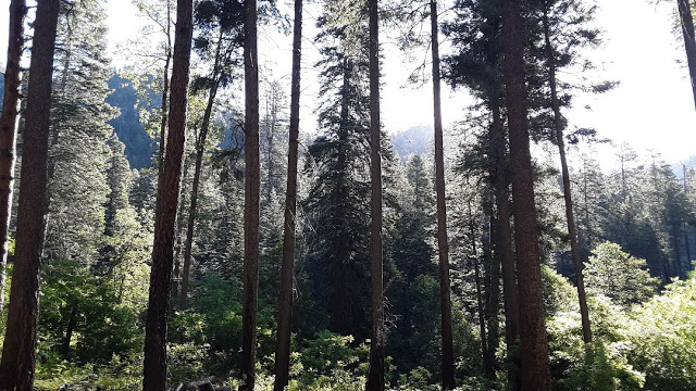
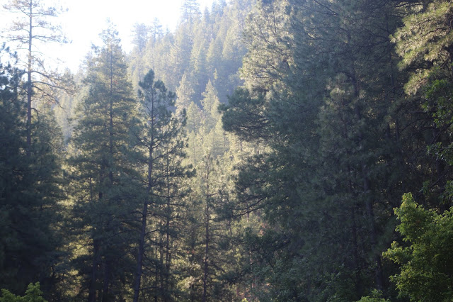
This area is home to some of the highest country in Gila County as the highlands fall below and adjacent to the ridges of the Mogollon Rim, which is the defining edge of the Colorado Plateau, as well as Coconino County. While Coconino County sits at the tip of the Rim and above, everything that falls below the Rim is Gila County. Along with the Whispering Pines, Washington Park, and Pine and Strawberry areas, this area adds to the many birding locations that can be explored right below the Rim. Highway 260 takes us east and north-east of Payson to these fine locations. Locations that are visited in this area harbor a diversity of habitats that include mid to high elevation riparian woodlands, chaparral and juniper slopes, open and dry forests of ponderosa pine, oak, and juniper, solid pine and oak forest, and denser coniferous forests and canyons that are dominated by pine and fir. Drainages that run south from the Mogollon Rim offer some of the best birding opportunities within this section of Gila County.
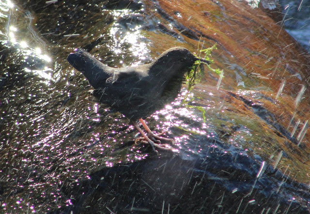
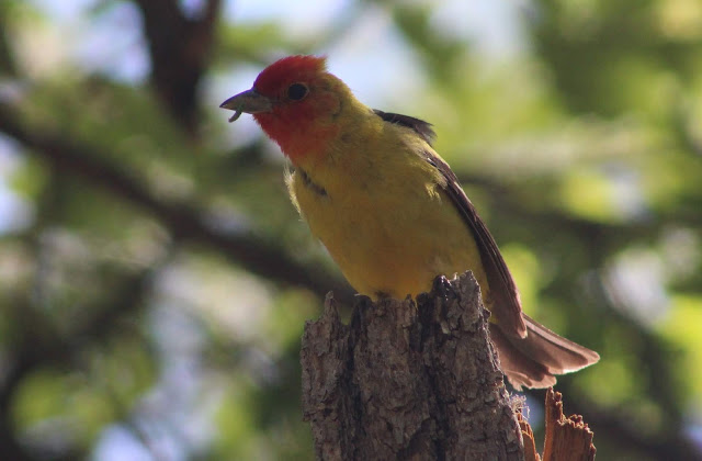
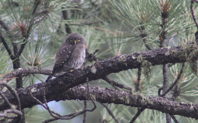
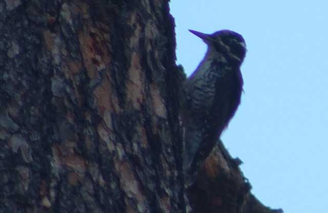
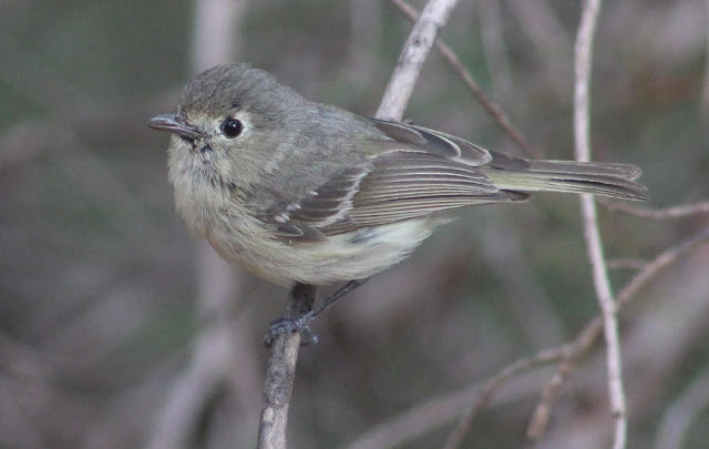
The birds of this area come at a solid diversity, and on a Gila County scale, this area holds a few species that could be considered Gila County "specialties". One of the most well-known birds here are wintering American Dippers. During most years, several American Dippers can be found along Upper Tonto Creek near the fish hatchery and at times further south along the Creek. They've also been found at the nearby Horton Creek, and birders have made trips to this area to get their lifer American Dipper. Another interesting bird for Gila County in this area is the American Three-toed Woodpecker. This is the only area they have been found at in Gila County, they are difficult to find, and almost all of the records have come from a general portion of Colcord Road just below the Mogollon Rim. As well as all of the other birds go that can be found in this area, well, they are pretty awesome too! Exploring these locations will include species like Wild Turkey, Band-tailed Pigeon, Common Nighthawk, Mexican Whip-poor-will, Sharp-shinned Hawk, Common Black-Hawk, Zone-tailed Hawk, Flammulated, Spotted, and Northern Pygmy-Owls; Williamson's Sapsucker, Acorn, Hairy, and Downy Woodpeckers; Greater Pewee, Gray Flycatcher, Hutton's, Plumbeous, and Warbling Vireos; Steller's and Mexican Jays, Mountain Chickadee, Bridled Titmouse, Purple Martin, Violet-green Swallow, Brown Creeper, Canyon Wren, Western Bluebird, American Robin, Olive Warbler, Chipping Sparrow, Dark-eyed Junco, Spotted Towhee, Virginia's, Red-faced, Black-throated Gray, and Grace's Warblers, Painted Redstart, Hepatic and Western Tanagers, and many more.
Directions: For the directions in this birding area, we'll use Payson as the base point at the intersection of Highway 87 and Highway 260, which is right in the middle of town. From Highway 87, Highway 260 will be traveled east towards the Mogollon Rim in order to access these birding locations. For each birding location/area, mileages will be given from this interection in Payson.
BIRDING LOCATIONS
Ponderosa Campground to Bear Flat
-Ponderosa Campground and FR 405-A to Bear Flat Recreation Site: This section of the area may be a fun one to explore, and it needs birding data. Open and dry ponderosa pine and oak habitat fill up much of the route, and chaparral and juniper habitat is also plentiful as one drives down in descending elevations toward Bear Flat. From the Highway 87/260 intersection in Payson, head east on Highway 260 for 12.9 miles, and the turnoff for Ponderosa Campground (eBird hotspot) will be on the south side of the road. Turn toward Ponderosa Campground and head south for an immediate turnoff to the campground, or keep going further south. Ponderosa Campground is well named, and can be a spot to bird at within pine and oak forest. If going south on the road past the campground, keep going for a little over a half-mile to the turnoff to Forest Road 405-A, and turn east (right). Take this road for about four miles. It passes through stands of pine and oak forest before dropping down in elevation en route to Tonto Creek where the Bear Flat Recreation Area is accessed. Before dropping down on switchbacks toward Bear Flat, look for Bearhide Group Site (eBird hotspot) after 2.4 miles after turning onto FR 405-A. Bear Flat is labeled as a campground on maps and such, but is much more of a day use recreation area. The valley that Tonto Creek runs through at this point is private after the road crosses the street and there is a community. The riparian habitat within pine and oak woodland at Bear Flat Recreation Site (eBird hotspot) is worth exploring during a morning, but on weekends it may be crowded with swimmers.
Upper Tonto Creek and Kohl's Ranch
For this area, head east on Highway 260 in Payson for 16.2 miles past the Highway 260/87 intersection. When arriving at this location off of Highway 260, the turnoff to Kohl's Ranch will be on the south side of 260, and access to Upper Tonto Creek for a four mile route toward the Tonto Creek Fish Hatchery will be on the north side of 260.
-Kohl's Ranch: After turning south from 260 onto the road into Kohl's Ranch, it is a short drive to the ranch. Much of the location is private, but there is a parking area and a few pleasant trails to hike on that go up and down in elevation through pine and oak forest south of the parking lot and ranch.
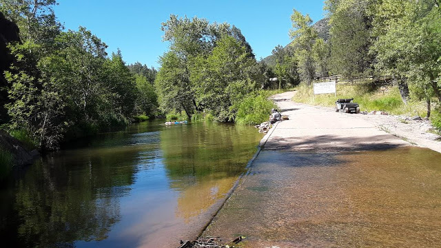
The remainder of the described birding locations for this section of the area will be on the north side of Highway 260 by taking the paved road north, which is FR 289, (signed as Zane Gray Highway on Maps) to it's dead end at Tonto Creek Hatchery. Tonto Creek is at or nearby all of these locations. Sycamore, cottonwood, and other mountain riparian trees line the creek in midst of coniferous and oak forest.
-Upper Tonto Creek Day Use Area: This site is an almost immediate 0.2 miles north after turning north of 260 on FR 289/Zane Gray Highway. It'll be on the left side of the road, and despite the noise level from Highway 260, can make for a productive stop along the way to the Hatchery.
-Derrick Trailhead: After driving north of 260 on FR 289/Zane Gray Highway, the Derrick Trailhead accesses the Derrick Trail and takes one through a significant portion of habitat to bird. An eBird hotspot is available for the Derrick Trail, click on the link HERE.
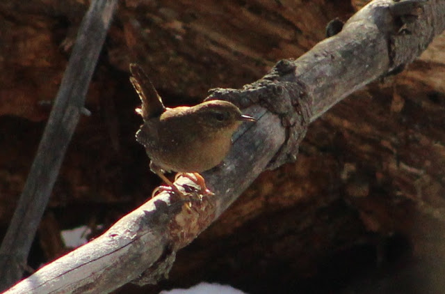
-Horton Creek Trailhead and Trail: The parking lot for access to the Horton Creek Trail will be on the left side of FR 289/Zane Gray Highway after 0.8 miles after turning north from Highway 260. After parking at the parking lot, walk across FR 289 toward the nearby campground, and trailhead can be found that way. This trail goes for about four miles to the beautiful Horton Creek Falls. Along the way, Horton Creek is a beautiful place to walk along. Thick coniferous forest of both pine and fir fill shady draws near the creek, and drier pine, oak, and juniper forest fill surroundings. American Dipper, Pacific Wren, and Winter Wren have been found along the trail and creek during late fall and winter in addition to a selection of commoner forest birds.
-Tonto Creek Fish Hatchery: This is truly an awesome location to bird at any time of the year, and about 120 species of birds have been recorded here. The Tonto Fish Hatchery comes right after four miles of driving north of 260 when FR 289 ends. Adjacent to the Hatchery, Tonto Creek as a variety of riparian trees along the creek in midst of thick coniferous forest. At times the winter months will host an American Dipper or two in the pools of water along Tonto Creek immediately near the hatchery. They have been seen carrying nesting material and building nests, but other than that, they haven't been documented here or anywhere else in Gila County as a confirmed breeder to date. Winter also brings in birds like Pacific Wren and Golden-crowned Kinglet. In spring and summer (as well as year round for some) look for a cast of birds that include Broad-tailed Hummingbird, Osprey, Common Black-Hawk, Belted Kingfisher, Acorn, Downy, and Hairy Woodpeckers; Western Wood-Pewee, Cordilleran Flycatcher, Cassin's Kingbird, Plumbeous, Hutton's, and Warbling Vireos; Mexican Jay, all three Nuthatches, Brown Creeper, Virginia's and Grace's Warblers, Painted Redstart, Western Tanager, and Black-headed Grosbeak.
Christopher Creek Campground, See Canyon, Sharp Creek, and Two Sixty Trailhead
-Christopher Creek Campground: This campground is on the south side of Highway 260, 20 miles east past the Highway 260/87 junction in Payson. It is a location that is very well named, as Christopher Creek runs through the heart of the campground. Pine and oak dominate the northern half of the overall area, Sycamore riparian habitat lines the creek, and stands of Douglas fir are along the south side of the campground as it backs into a north-facing slope. Besides camping here, the ground is also used as a day use area. There is a fee involved to park at and use the location for day use. At the eastern side of the campground, follow a trail that goes along the north side of Christopher Creek in the eastern direction. Continue for about a half-mile and Christopher Creek will bend north as it intersects with Hunter Creek and Christopher Creek will enter the mouth of See Canyon with it's change in direction. Follow this more secluded section of Christopher Creek for awhile.
-See Canyon: See Canyon harbors the upper section of Christoper Creek. The southern base of this canyon is just east of Christopher Creek Campground, and it extends north up to the Mogollon Rim. The canyon has wide and narrow stretches as it increases in elevation, which results in noticeable elevation changes. See Canyon is one of scenic beauty, and luckily a hiking trail called the See Canyon Trail # 184 traverses through the upper half of the canyon. The See Canyon Trailhead accesses this trail and a few other montaneous trails that have good birding. To get to the See Canyon Trailhead, take Highway 260 for 20 miles east of Payson (past the Highway 260/87 junction) and turn left onto Christopher Creek Loop Road (which is just past and east of the turnoff to Christopher Creek Campground). Take Christopher Creek Loop Road for 1.1 miles to Forest Road 284, which veers north. Take FR 284 for 1.6 miles until it ends at the See Canyon Trailhead. The See Canyon Trail can be hiked for about four miles through Gila County until it goes above the Mogollon Rim into Coconino County. See Canyon is wide at the start of the trailhead and is in midst of more open coniferous and oak woodlands. As one hikes further north up the trail, the canyon continues to narrow. The upper elevations of the trail have thicker mixed coniferous and aspen forests. Williamson's Sapsucker, MacGillivray's Warbler, and Spotted Owl have been detected in the upper parts of this canyon in appropriate breeding season. The course of the hike will give the birder a solid list of high elevation forest birds, as well as great numbers for species like Cordilleran Flycatcher, Warbling Vireo, House Wren, Red-faced Warbler, and Western Tanager. In addition to the main See Canyon Trail # 184, there is also the See Springs Trail # 117 (eBird hotspot). This trail is a much shorter trail and can be hiked for about a mile. It goes along another creek, which flows into Christopher Creek,that is fed by See Spring. This trail is beautiful, and travels through montaneous riparian habitat along the creek and through coniferous and oak forest. A day of hiking both of these trails makes for a great hike and exploring for birds.
-Sharp Creek and Campground: Drive 22.6 miles east of Payson/Highway 87 on Highway 260 and look for Sharp Creek Campground on the south side of 260. To the east of the campgrounds (east and below the group campgrounds to be more specific) is Sharp Creek. Sharp Creek has times of the year where water is running, and times when it isn't. Regardless, it's a place to explore and there are roads to hike along that are above and beyond the creek. A day use fee may apply here, even though it isn't stated anywhere. Before the group campgrounds are accessed, there is a pull off on the north side of the road through the campground. Park here and walk down the road to the east to access Sharp Creek. This is a good place to see and hear Purple Martin in spring and summer, and look for birds that favor pine and oak forests such as Hairy Woopecker, Plumbeous Vireo, Violet-green Swallow, Pygmy Nuthatch, "Red-backed" Dark-eyed Junco, Olive Warbler, and Grace's Warbler.
-Two Sixty Trailhead: From Payson at the Highway 260/87 intersection, head east on Highway 260 for 25.8 miles. On the north side of the road is the Two Sixty Trailhead. From this trailhead, take the Sinkhole Trail # 179 in the northeast direction toward the Mogollon Rim. The trail quickly goes from open pine, oak, and juniper forest into a narrow drainage with thick pine and fir, oak, and mountain riparian forest. It is a beautiful spot to hike along, and in spring and summer, look and listen for birds like Broad-tailed Hummingbird, Cordilleran Flycatcher, Warbling Vireo, Brown Creeper, House Wren, Hermit Thrush, Virginia's, Grace's, and Red-faced Warblers; Western Tanager, and Black-headed Grosbeak.
Colcord Road (west) and Haigler Creek areas
-Colcord Road/FR 291 (western side): Colcord Road is at 24.3 miles of driving on Highway 260 east of Payson after the Highway 260/87 intersection. The turnoff to Colcord Road (also known as FR 291) will be on the east side of Highway 260. This road has a mix of both forest land and private properties along it's length. Colcord Road starts off as a paved road for it's early stages before becoming a solid dirt road for the rest of it's length. Along the road the habitat consists of pine, oak, and juniper forest during the first five miles. Roadside birding can be productive here. Despite that the roadside birding may be solid along Colcord, this road accesses several amazing locations. Colcord Road will be split in half on Birding in Gila County. The western half of the road will be described in this area, and the eastern half of the road will be described in the "Canyon Creek to Young" area. Colcord Road runs from west to east for about thirteen miles. In the western half of Colcord after five miles of drivig, the road narrows a lot, is more rough but still drivable for almost all vehicles, and goes to the south and bends to the eastern direction for the rest of it's length. It goes up and down in elevation in places before ending at the Young Highway (Forest Road 288/512). The western half of the first seven miles of the road will be described here. After driving into the Colcord Road area for about one mile east of Highway 260, pay attention to small jeep and forest roads that peter off north of Colcord Road. These roads take one up onto slopes that are higher in elevation and some of the roads go very close and just below the Mogollon Rim. Thicker stands of pine and Douglas fir are up along these roads in places. American Three-toed Woodpecker has been found in this area on several locations, and they are worth exploring these roads for as they're range barely enters into Gila County below the Mogollon Rim. One such road where Three-toed Woodpeckers have been found is on the north side of Colcord Road and adjacent to Running Elk Road. Look on a map to see a longer road extending to the northeast toward the Mogollon Rim at this point. It is steep in places and climbs up into a mixed forest that has some burned areas in midst of the rest, which is what Three-toed Woodpecker often favors. An eBird list for the road can be found HERE, and it represents a handful of roads in this area that can be explored as well as surveying for more of these woodpeckers in Gila County. Colcord Road has good cell phone reception, and it helps to study maps at home.
*Forest Road 200 (north) to Haigler Creek Area
-Forest Road 200/Chamberlain Trail: Forest Road 200, also known as Chamberlain Trail, is another longer forest road (in decent shape for most vehicles) that runs for 16 miles with the northbound limit of the road starting at the western side of Colcord Road, and the southbound limit coming out to the Young Highway just north of the town of Young. In similar ways to Colcord Road, this road will also be split up into two, with the northern half being in this area and the southern half being in the "Canyon Creek to Young" area. To get to Forest Road 200 for this area, take Colcord Road east for about four miles from Highway 260. Forest Road 200, well signed off and labeling places like Haigler Creek, will be on the south side of Colcord Road. For the northern half of this road (just over eight miles of driving south), FR 200 will travel through mixed coniferous and oak forest and will drop lower into elevation where habitats are dominated more by juniper and chaparral components. Although Haigler Creek's riparian habitats are a fun draw to birding in this area, these northern eight miles of this road have many side roads along them and roadside locations that are worth birding, and could use solid eBird data!
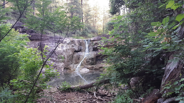
-Forest Road 848 to Haigler Creek: From Colcord Road, take Forest Road 200 south for 4.4 miles. There will be two roads on the east and west side of FR 200 at the 4.4 miles, with the eastern one being FR 848. This is a spectacular area to bird at and explore, as FR 848 extends down and to the southeast towards the upper section of Haigler Creek with a hike through the narrow Naegelin Canyon. Drive carefully with a high quality high clearance vehicle or take the preferred choice in hiking down FR 848 for about 1.5 miles down toward Haigler Creek. En route to the creek, the habitat is highly composed of chaparral and juniper before dropping into conifer and oak forests. High numbers of Spotted Towhee will be present, as well as birds like Blue-gray Gnatcatcher, Rufous-crowned Sparrow, and Black-chinned Sparrow along this first stretch. Once getting down to Haigler Creek, FR 848 continues for another mile or so, crossing the beautiful Haigler Creek several times. Once getting to the creek, it would be hard for any vehicle to access the road in certain places, especially where the road crosses the creek. Once at the level of Haiger Creek and entering the narrow Naegelin Canyon, thick mixed coniferous and oak forest fills up both slopes of the canyon, and the creekside mountain riparian habitat is impressive. The beauty of this area is worth the trip alone, and most high elevation coniferous species will be encountered here. Hike along the road right along Haigler Creek for as long as possible, and Haigler Creek continues to be straightforward to follow to the east past FR 848's ending point. If birding this area seriously, bring an old pair of shoes to get wet for when Haigler Creek has to be crossed several times. At a point where Colcord Canyon comes into contact with Naegelin Canyon, a beautiful waterfall flows into Haigler Creek and makes for a swimming pool. The described hike for this area is over three miles one way. Prepare safely when coming to this remote area.
-Fisherman's Point Trail to Haigler Creek: From Colcord Road, take Forest Road 200 south for 5.2 miles. A pull off on the right side of FR 200 introduces this spot, and a steep and extremely strenuous trail goes down (and eventually back up of course) for just over a half-mile to another section of Haigler Creek. The elevation here is lower than the previously described location, and there is a much drier pine, oak, and juniper forest near the creek.
-Haigler Canyon Recreation Site: From Colcord Road, take Forest Road 200 south for 7.6 miles to reach this recreation site. This location features a campground and a day use area, in which a fee is required for both. This place is lower in elevation than the previous two Haigler Creek access points, and at this point Haigler Creek has habitat nearby that highly consists of juniper and chaparral. The creekside riparian that consists of sycamore, cottonwood, and more is impressive and would be a good spot to check throughout the year, especially during spring and fall migration periods. Some of the birds that may be seen here include Acorn Woodpecker, Hutton's Vireo, Woodhouse's Scrub-Jay, Mexican Jay, Bridled and Juniper Titmice, Bewick's Wren, and Spotted Towhee.
Back to Birding in Gila County |


