Coronado Trail Area (Highway 191)
The scenic Coronado Trail, which is a section of Highway 191, is a National, State, and Forest Service Scenic Byway. It goes from Clifton and Morenci on the south, and past Hannagan Meadow and Alpine to the north. It is a breathtaking, slow, and windy route through high desert, mountains, forests, and more. This section of the birding guide will cover areas that are worth birding to the north of the Clifton and Morenci mining area. Those birding areas will continue north to the southern sections of the White Mountains, south of Hannagan Meadow (White Mountains are another area in this guide). This area represents one of the most underbirded sections of Arizona.
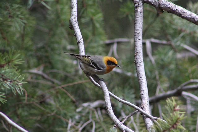
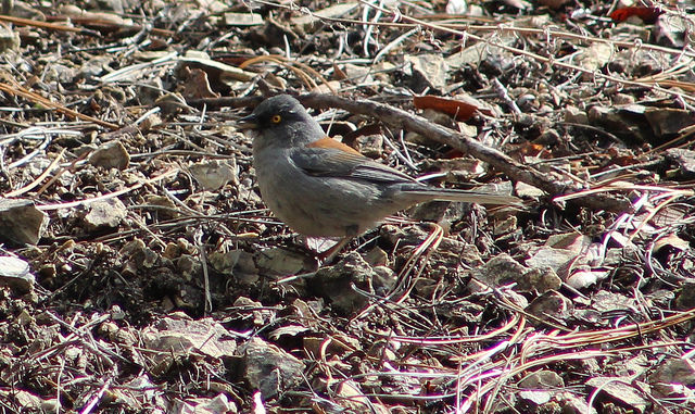
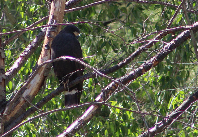
Birds and habitat you may see in the Coronado Trail Area: There are a wide variety of birds that will be encountered within the birding locations described within this area. Because this area is poorly birded and has rarely been covered, many of the locations will simply be strong suggestions of where to go and explore. Habitats found in this area will include desert scrub, chaparral, oak and juniper woodland, Great Basin grassland, pine and oak forest, mixed pine and fir forest, and mixed conifer and aspen forest. Riparain corridors will range from just over 4000' to above 6000' in the area. Lower elevation riparian is probably dominated by cottonwood and willow forests with sycamore along Eagle Creek and the Blue River, and the higher elevation riparian will have sycamore as one of the more common riparian trees. Birds to look for along the riparian corridors of locations such as the Lower Blue River and Upper Eagle Creek include Common Black Hawk, Zone-tailed Hawk, Yellow-billed Cuckoo, Western Screech and Elf Owls, Black-chinned Hummingbird, Gila and Ladder-backed Woodpeckers, Black Phoebe, Vermilion Flycatcher, Ash-throated and Brown-crested Flycatchers, Cassin's Kingbird, Bell's Vireo, Bridled Titmouse, Rock, Canyon, and Bewick's Wrens; Phainopepla, Yellow and Lucy's Warblers, Song Sparrow, Yellow-breasted Chat, Summer Tanager, Blue Grosbeak, Hooded and Bullock's Orioles, and Lesser Goldfinch. In chaparral areas along the begining stretch past the Clifton and Morenci mine, look for birds such as Black-chinned Sparrow, Rufous-crowned Sparrow, Gray Vireo, Scott's Oriole, Spotted and Canyon Towhees, and Crissal Thrasher. Oak and juniper areas include species such as Juniper Titmouse, Woodhouse's Scrub-Jay and Black-throated Gray Warbler. More than half of this area is made up of higher elevations with different forest types such as pine and oak forest, mixed coniferous woodlands of pine and fir. Higher elevations of the latter have aspen in the midst. These forests may have common and widespread species in every habitat example. Pine and oak forests and some of their surrounding outskirt habitats support species that include Montezuma Quail, Northern Pygmy-Owl, Mexican Whip-poor-will, Broad-tailed Hummingbird, Acorn Woodpecker, Western Wood-Pewee, Hutton's Vireo, Mexican Jay, Bridled Titmouse, Olive Warbler, Virginia's Warbler, Grace's Warbler, Painted Redstart, and Hepatic Tanager. In the higher mixed conifer forests that have pine and fir with mixed in aspen, some of the species found there include Wild Turkey, Northern Goshawk, Band-tailed Pigeon, Flammulated, Northern Saw-whet, and Spotted Owls; Common Nighthawk, Hairy Woodpecker, Cordilleran Flycatcher, Plumbeous and Warbling Vireos, Steller's Jay, Mountain Chickadee, Red-breasted Nuthatch, Brown Creeper, Red-faced Warbler, Chipping Sparrow, Dark-eyed Junco, Western Tanager, and Black-headed Grosbeak. What has been described here falls under the category of breeding birds. Visiting these places at different times of the year such as in migration or in winter will add more birds to the diversity of what can be seen in this area.
Area covered in this area: This area will fall within locations that can be accessed along Highway 191 directly or within a short distance from 191, and locations will also include those that are a longer drive from Highway 191 but need to be accessed from 191. Examples of the latter include Upper Eagle Creek and Lower Blue River. From south to north along Highway 191, this area will refer to Clifton as the starting point to the south as the base point for the route, and the area will reach it's northern limit after taking Highway 191 for 52.5 miles north when it comes into contact with the Sheep Saddle Trailhead.
Area Elevation: Along Highway 191 (Coronado Trail), Clifton is at 3500' as the southern point of the route. The northern point of the route, the Sheep Saddle Trailhead, is at 7,300'. The route is windy and has many switchbacks and numerous climbs. Elevation tops out at over 8300' at several points along the route, south of Sheep Saddle Trailhead. Elevations for different locations within this area are: Cherry Lodge Picnic Site (6500'), Granville Recreation Area (6500'), Sardine Saddle and HI Saddle (7300'), Upper Eagle Creek (4800'-5500'), Juan Miller Campgrounds (5800'), Lower Blue River (4200'), and Hogtrail Saddle Road (7100'-8200').
Base Point for directions: Town of Clifton
Area Maps: Coronado Trail Area (Highway 191) Maps
Birding Areas: Birding areas will all be north of Clifton and Morenci Mining area, Clifton is simply used as a base point. Most of these areas are very underbirded, and the ones listed below are highly suggested to be explored. On another note, there will be many places along Highway 191/Coronado Trail other than what's listed on here than can be birded or explored. If you see a spot that looks interesting, check it out!
1. Grand Enchantment Trail and Fry Trailhead: Take Highway 191 for 17.8 miles past Clifton. Look for a road signed, Grand Enchantment Trail, on the right (east) side of 191. Take Grand Enchantment Trail about a mile to the Fry Trailhead and parking area. There are trails to hike here. Oak, juniper, and chaparral habitat look to be present. A trail to the north goes to a small riparian area, Upper Cove Creek Spring. Further north is Shorty Spring and Fry Canyon. If getting back onto Highway 191 and contuning northbound for another 0.7 mile, look for Forest Road 13 on the south (left) side of 191. This looks to have interesting exploring too, with some canyons filled with oaks. This is another side to the Grand Enchantment Trail.
2. Cherry Lodge Picnic Site: At 6500' in elevation is the Cherry Lodge Picnic Site on the left (west) side of Highway 191 at 19.7 miles past/north of Clifton. This Picnic Area has good potential for birds, with tall oak and some pine .
3. Granville Recreaton Area: A very interesting location is Granville Recreation Area. Take 191 north/past Clifton for 20 miles and look for a turnoff into Granville Recreation Area and Campground on the east (right) side of 191. Granville Recreation Area has a campground and a few trail heads. Tall oaks make up most of this area, but there are spots that have pine, fir, and sycamore. Look for Olive Warbler and Red-breasted Nuthatch among the more common pine and oak species. There is a drainage on the west side of the campground that has a mix of pine, fir, and oak. This is where Highway 191 takes a sharp southwest turn and immdietely turns sharply to the east. Caleb Strand found Greenlee County's first known Yellow-eyed Junco here in February of 2017. Drive further into the campground at Granville to bird the campground loop or take a narrow road to the northeast of the campground to access the Granville Trailhead. Just southwest of Granville Trailhead is Spur Cross Trailhead. Spur Cross Trailhead is more conveniently reached by taking Highway 191 shortly north past the mentioned sharp southwest turn . A parking area for Spur Cross is on the west side of the Highway.
Granville Campground on eBird
4. Sardine Saddle Picnic Area and Hi Saddle Picnic Site: This is an area with some interesting pine and oak drainages nearby. Take Highway 191 north/past Clifton for 22.6 miles, and the picnic area will be on the east (right) side of 191. The picnic area is at an elevation of about 7200'. The Big Tree Trailhead is on the north side of the picnic area, and there are several trails to hike within this location. Shortly further north is HI Saddle Picnic Site. This site looks to have a mix of oak, chaparral, juniper and some pine nearby at an elevation over 7300'. Take Highway 191 north/past Cliftion for 23.5 miles to reach HI Saddle Picnic Site, which will be on the south (left) side of 191.
5. Eagle Creek Road and Upper Eagle Creek: 29.3 miles north/past Clifton on Highway 191 is the turnoff for Eagle Creek Road (Forest Road 217) on the west (left) side of 191. Eagle Creek Road, which is a dirt road, starts off in juniper/pinyon pine woodland and descends down into the reaches of Upper Eagle Creek. This road can be taken for 10.8 miles until the road parallels Eagle Creek. It passes through habitat that may be worth birding, including some interesting grassland. Eagle Creek Road intersects with Forest Road 515 after 9.5 miles, stay on Eagle Creek Road. Once Eagle Creek Road drives alongside Eagle Creek after 10.8 miles, it continues to parrallel the creek for it's ending limit at nearly 22 miles. The northern limit ends at Lower Squirrel Trailhead and Honeymoon Campground. In the 11 miles that one can drive along Eagle Creek Road, there are many points along the route where the road crosses the creek. Times of the year may prove for the creek to be unpassable. Use caution when exploring this very remote area. Graham County lies just to the west of Upper Eagle Creek for most of the route. Elevation goes from 4800' to close to 5500' immediately along Eagle Creek for the 11 miles. There are ranches and private properties along the route, also. Birding knowledge is very unknown from this area, but it clearly has awesome potential along Eagle Creek.
6. Upper and Lower Juan Miller Campgrounds: Drive 30.1 miles north/past Clifton on Highway 191 to Jaun Miller Road (Forest Road 475), which will be on the east (right) side of 191. Juan Miller is a dirt road. Upper Juan Miller Campground and Picnic Area is accessed after driving for 1.1 miles east on Juan Miller Road, and Lower Juan Miller Campground is accessed after 1.5 miles of driving east on Juan Miller Road. This is a very interesting area, with a habitat mix of pine, fir, oak, and sycamore. Interesting birds that have been found here have included Montezuma Quail, Elf Owl, Mexican Whip-poor-will, and Dusky-capped Flycatcher. Late spring and summer would be the best time to bird this promising area. Elevation at both of the Juan Miller Campgrounds is roughly 5800'.
Juan Miller Campgrounds on eBird
7. Lower Blue River and Turkey Creek: This area is also on Juan Miller Road, see directions in previous spot on getting to Juan Miller Road. The Blue River is the main point of interest, and this lower section of the Blue River has lots of potential and lots of unknown knowledge about it's bird life. Unlike the northern section of the Blue River, the elevation here is much lower, and is roughly 4200'. Expect birds typical of this elevation, which would could be similar to those in the riparian areas of the Clifton and Morenci areas in riparian habitat along Lower Eagle Creek and Gila River. Take Juan Miller Road from Highway 191 for 13.7 miles until Juan Miller comes into contact with and crosses the Blue River. At this crossing, try and explore the Blue River to the north and south. Juan Miller Road continues on and ends at a ranch after 15 miles. Another interesting spot in this area is Turkey Creek, which intersects Juan Miller Road before the Blue River and 8 miles east of Highway 191. Juan Miller crosses Turkey Creek here, and Turkey Creek has good riparian habitat in both north and south directions. Depending on access (there looks to be nearby property), Turkey Creek would be an interesting spot to check out too.
8. Grasslands: After 33 miles of driving north/past Clifton on Highway 191, the highway passes through some great grassland habitat. There are many water tanks out in this area. Depending on access, these grasslands would be worth exploring thoroughly during different seasons for Short-eared Owl, Sprague's Pipit, longspurs, Rough-legged Hawk, and more. Highway 191 runs from south to north for almost 3 miles along this habitat. Surrounding pinyon-pine and juniper woodland may host Pinyon Jay.
9. Rose Peak Area: 47.6 miles north/past Clifton on 191 is the turnoff to the Rose Peak Recreation Area on the east side of 191. Rose Peak exceeds 8700', and one may hike up for over a mile to the summit, which has radio towers and restrooms. If workers are present, the road to the summit may be open to vehicles at times. From the parking area, one may take two different roads: one a well-established dirt road that veers to the southwest and climbs up to Rose Peak, and the other a road ment for hiking only that continues for up to four miles. Habitat here consists of pine and oak woodlands, and there are aspens near the summit. Strayhorse Creek and Spring are directly east of the parking area. Finally, there is a marked hiking trail on the west side of 191, roughly 47 miles north of Clifton on 191, called Adbar Trail Fourteen, which may also be worth exploring.
10. Sheep Saddle Trailhead and Picnic Site: This is the northmost location listed in this birding area, and it falls within the Blue Range Primitive Area. Sheep Saddle Trailhead is on the east (right) side of Highway 191, 52.5 miles north/past Clifton on Highway 191. Sheep Saddle is also 18.6 miles south of Hannagan Meadow via Highway 191. Ponderosa pine and oak woodland make up the habitat here as trails go through the area. A pull off is adjacent to the Trailhead and is on the west side of the highway.
Area Maps: Coronado Trail Area (Highway 191) Maps
Back to Greenlee County Birding Areas |


